Morning Sun; A Few Afternoon Storms
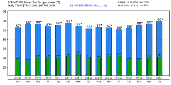
TYPICAL JUNE WEATHER: A muggy, maritime tropical airmass covers Alabama and the Deep South this morning, and we expect more routine early summer weather through tomorrow. Partly sunny, humid days with a few scattered showers and storms around, most all of the coming during the peak of the daytime heating process between 2:00 and 9:00 p.m. The high resolution HRRR model hints the most numerous showers and storms today will be over the southern half of the state, but we will have a few around across the northern counties as well. Chance of any one spot getting wet today across North/Central Alabama is about one in four. And, like yesterday, the storms will be totally random and will move slowly and erratically. The high today and tomorrow will be in the upper 80s for most places.
THURSDAY/FRIDAY: Moisture will be a bit deeper, the air aloft a little colder, and the air more unstable, so scattered showers and storms should be a little more numerous on these two days with any one spot having a 50/50 chance of seeing rain. While most of the showers and thunderstorms will come during the afternoon and evening hours, we can’t totally rule out a rogue late night or morning shower in this environment. Highs will be in the mid to upper 80s, and the sun will be out at times.
THE ALABAMA WEEKEND: Pretty much the same situation Saturday. Very warm, very humid, a mix of sun and clouds, and scattered showers and thunderstorms, mostly during the afternoon and evening hours. The GFS model is hinting the air could be a little drier Sunday with fewer showers around, but we will believe that when we see it. Highs over the weekend will be in the mid to upper 80s. Understand there is no skill in resolving specific placement and timing of the afternoon showers; they will be very random.
NEXT WEEK: The GFS tries to bring a cold front down into Alabama Monday, followed by drier, continental air Tuesday and Wednesday, but remember cold fronts have a hard time making it that far south in mid to late June, so we won’t buy into that solution just yet. Temperatures next week remain close to seasonal averages with highs in the upper 80s and lows in the low 70s.
TROPICS: The Atlantic basin will remain quiet this week, but global models continue to show potential for a tropical low to form over the far Southwest Gulf of Mexico next week. For now, they drift the system westward into Mexico… but it is simply way too early to know if anything forms at all, and the ultimate destination. See the Weather Xtreme video for maps, graphics, and more details.
BEACH FORECAST: Click here to see the AlabamaWx Beach Forecast Center page. The Beach Forecast is partially underwritten by the support of Brett/Robinson Vacation Rentals in Gulf Shores and Orange Beach. Click here to see Brett/Robinson’s Own Your Summer specials now!
WEATHER BRAINS: Don’t forget you can listen to our weekly 90 minute netcast anytime on the web, or on iTunes. This is the show all about weather featuring many familiar voices, including our meteorologists here at ABC 33/40.
CONNECT: You can find me on all of the major social networks…
Facebook
Twitter
Google Plus
Instagram
Pinterest
Snapchat: spannwx
Look for the next Weather Xtreme video here by 4:00 this afternoon… enjoy the day!
Category: Alabama's Weather, ALL POSTS, Weather Xtreme Videos


