A Quick Check On Central Alabama’s Weather At Midday
UNFORTUNATELY IT LOOKS TO BE A STORMY MEMORIAL DAY
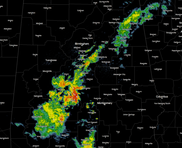
We currently have a broken line of showers and storms stretching from Cedar Bluff in Cherokee County back to the southwest through Columbiana in Shelby County to Grove Hill in Clarke County.
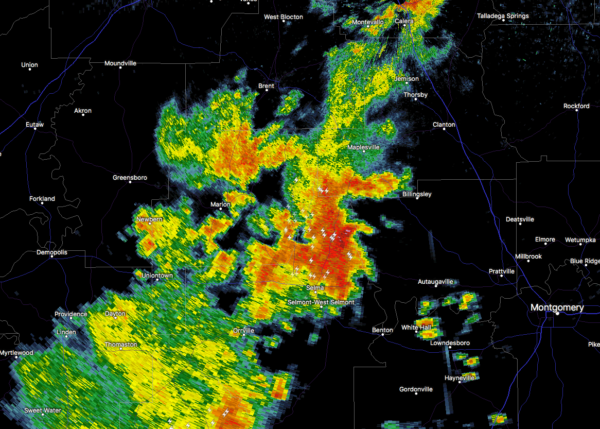
At this point, the strongest storm is affecting Dallas County and is about to move into the southern part of Chilton County and into Autauga County. This storm is moving to the northeast and is producing very heavy rainfall and dangerous lightning. This cell should stay north of Autaugaville, but will be in Billingsley and Clanton soon. Please go indoors until this storm passes.
REST OF YOUR MEMORIAL DAY
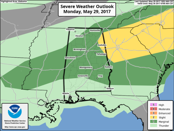
We will have mostly cloudy skies throughout the day, but a few peeks of sunshine are possible. We have a decent chance of showers and thunderstorms throughout the remainder of the day, but it will not rain all day. Just remember, “If thunder roars, go indoors.” Afternoon highs will be in the lower to mid 80s throughout Central Alabama. A few of these storms could be strong to marginally severe, with the main threat coming from strong to damaging thunderstorm wind gusts and possibly some small hail. The SPC has much of Central Alabama in a Marginal Risk for severe storms, with a few locations in the northeastern parts of the area in a Slight Risk. We will have a few showers and thunderstorms lingering throughout the evening and into the overnight hours tonight. Lows will be in the mid 60s to the lower 70s across the area.
WE GO BACK TO WORK ON TUESDAY, AND SHOWERS/STORMS WILL CONTINUE
It looks to be another day featuring mostly cloudy skies with scattered to numerous showers and thunderstorms likely at times. Once again, it will not be a complete wash, but expect rain at times. Afternoon highs will be in the upper 70s to the lower 80s across the area.
BEACHBOUND
For a detailed look at the weather from Fort Morgan over to Panama City Beach, Click here to see the AlabamaWx Beach Forecast Center page. The Beach Forecast is partially underwritten by the support of Brett/Robinson Vacation Rentals in Gulf Shores and Orange Beach. Click here to see Brett/Robinson’s Own Your Summer specials now!
THURSDAY IS THE FIRST DAY OF THE 2017 ATLANTIC HURRICANE SEASON
That’s right! Hurricane season for the Atlantic Basin starts on Thursday. NOAA’s Climate Prediction Center is predicting that we could see an above-average year in the Atlantic… According to the forecasts, it is likely that there will be 11 to 17 named storms in the Atlantic basin, with 5 to 9 of those becoming hurricanes, with 2 to 4 of those possibly becoming major hurricanes. An average season usually have 12 named storms, with 6 of those becoming hurricanes, and 3 of those becoming major hurricanes. Tropical Storm Arlene, a rare pre-season storm that formed over the eastern Atlantic in April, has been accounted for in these numbers. I’ll start A Look In The Tropics in my midday forecasts on Thursday.
ON THIS DAY IN WEATHER HISTORY – 1953
One of the strongest tornadoes to ever strike North Dakota cut a 20 mile path of destruction through Fort Rice and into Emmons County. Almost every building in Fort Rice suffered damage, including the local Catholic church which was completely destroyed. The tornado reached 600 yards at its widest point while on the ground. Two people lost their lives during this monster twister. This is the first of two tornadoes that was given an F5 ranking, with the other one striking Fargo in June of 1957.
WEATHERBRAINS
Don’t forget you can listen to our weekly 90 minute netcast anytime on the web, or on iTunes. This is the show all about weather featuring many familiar voices, including our meteorologists here at ABC 33/40. We will produce this week’s episode tonight at 8:30… you can watch it live here.
Category: Alabama's Weather, ALL POSTS


