New Mesoscale Discussion from the SPC
The SPC lets us know what they are thinking with a product called a Mesoscale Discussion (MCD). They also serve as a heads up for watches that will be issued soon.
Weather service offices at Birmingham an Huntsville as well as others are currently on a conference call with the SPC about whether they will be issuing a watch shortly for parts of Alabama.
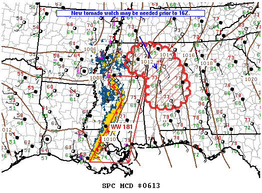
I am working on a full update on the Alabama weather situation for 11 a.m., but here is the graphic and text from the MCD:

SUMMARY…The threat for mainly isolated damaging wind and a few
tornadoes is expected to persist across the remainder of WW 181
including eastern MS and southeast LA. Based on current trends, a
downstream tornado watch will probably be needed prior to 16Z that
would include northeast MS and portions of central and northern AL.
DISCUSSION…Line of strong to severe storms continues advancing
east at 35-40 kt through MS with embedded organized structures
evident including meso-vortices as well as a book-end vortex and
bowing segment over central MS. The 12Z RAOB from Birmingham AL
showed limited instability, substantial capping inversion and weak
0-6 km vertical shear. However, winds aloft will gradually
strengthen farther east today as a mid-level jet rotates newd
through the eastern periphery of upper low circulation. Though
widespread multi-layer clouds will slow diabatic warming of boundary
layer, at least weak theta-e advection along the strong southerly
low-level jet and some cloud breaks should contribute to 500-1000
J/kg MLCAPE and weakening convective inhibition. These processes
might be sufficient to sustain a severe threat farther east into AL
into the afternoon.
Category: Alabama's Weather, ALL POSTS


