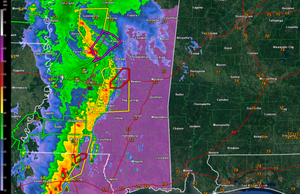
Tornadoes In Progress Across Mississippi

Radar at 9:20 a.m.
UPDATE 925 AM
Confirmed tornado 11 miles southwest of Durant, or south of Winona at 9:22. Will pass near of west of Kosciusko.
Tornado warning or Scott County, including Forest along I-20 east of Jackson.
ORIGINAL POST
Tornadoes are occurring across Central Mississippi this morning.
Here are some reports:
…8:46 AM Trees and power lines down along First Street near downtown Flora. Possible tornado. This is just northwest of Jackson.
…8:27 AM Trees down along US Highway 80 through Bolton. Definite indications of a tornado on the ground at the time. This is west of Jackson.
…8:03 AM Tornado reported just north of Utica. Home damaged and trees down.
…7:40 AM Trees down along High 61N 13 miles NNE of Vicksburg. Possible tornado.
…7:32 AM Trees down near Port Giblson. Tornado Debris Signature (TDS) observed.
…7:26 AM Trees down, power outages near Fayette in Jefferson County MS. TDS observed. Lots of trees and power lines across the county. Numerous power outages.
…7:16 AM Picture of tornado on the ground taken by law enforcement in Vicksburg. TDS also observed.
…7:00 AM Numerous trees down throughout Adams County near Natchez.
…9:00 AM Flash flooding reported in Vicksburg. Severe flash flood warnings are in effect over Southwest Mississippi. Areas from Natchez to the southwest exceeds four inches according to Doppler radar estimated.
Category: ALL POSTS, Severe Weather


