Tornado Warning Expired For Parts Of Pike County
…THE TORNADO WARNING FOR EAST CENTRAL PIKE COUNTY WILL EXPIRE AT
1145 AM CDT…
The storm which prompted the warning has moved out of the area.
Therefore the warning will be allowed to expire.
To report severe weather, contact your nearest law enforcement
agency. They will relay your report to the National Weather Service
Birmingham.
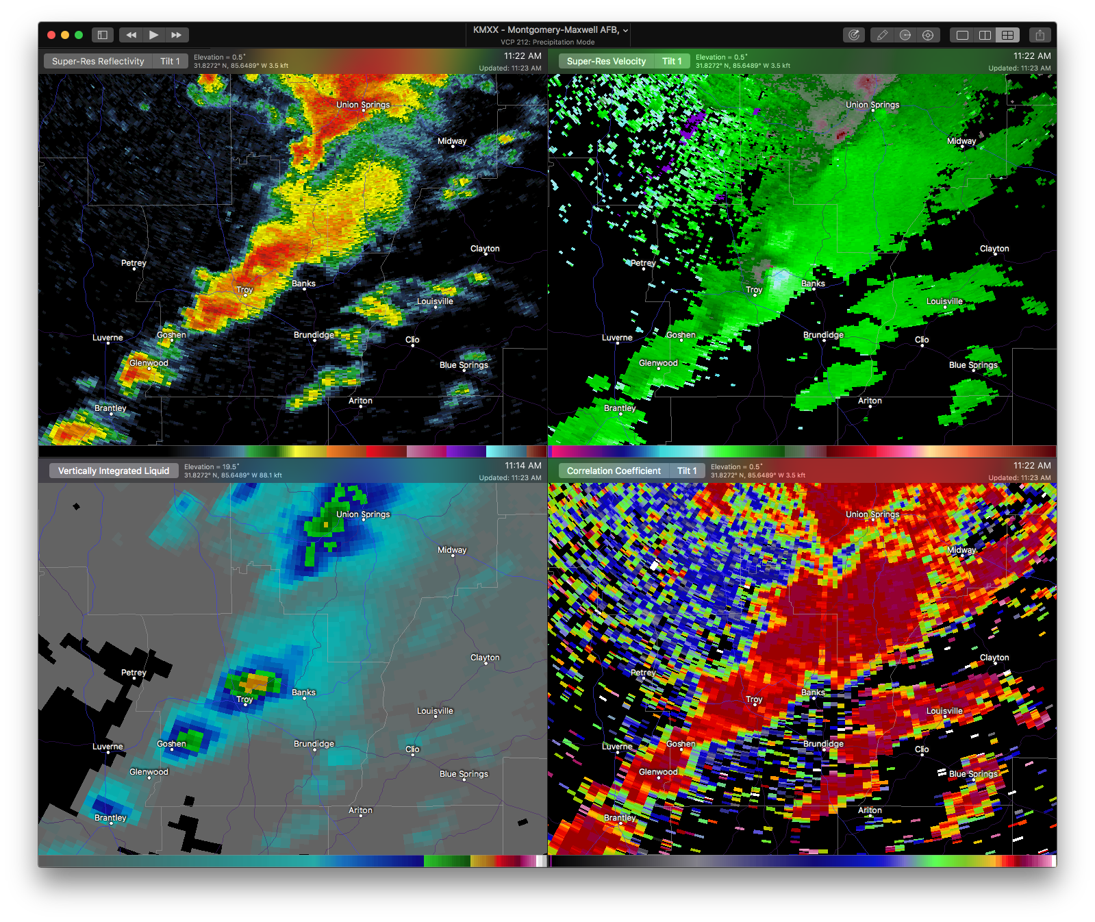
Tornado Warning Continues For Parts Of Pike County Until 11:45AM
Apr 27th @ 11:22 am
Pike County Sheriff reporting tornado on the ground. Take cover immediately!

…A TORNADO WARNING REMAINS IN EFFECT UNTIL 1145 AM CDT FOR EAST CENTRAL PIKE COUNTY… At 1134 AM CDT, a confirmed tornado was located near Linwood, or 8 miles northeast of Troy, moving northeast at 35 mph.
HAZARD…Damaging tornado and quarter size hail.
SOURCE…Radar confirmed tornado.
IMPACT…Flying debris will be dangerous to those caught without shelter. Mobile homes will be damaged or destroyed. Damage to roofs, windows, and vehicles will occur. Tree damage is likely. Locations impacted include… Sandfield.
Tornado Warning Continues For Parts Of Pike County Until 11:45AM
Apr 27th @ 11:22 am
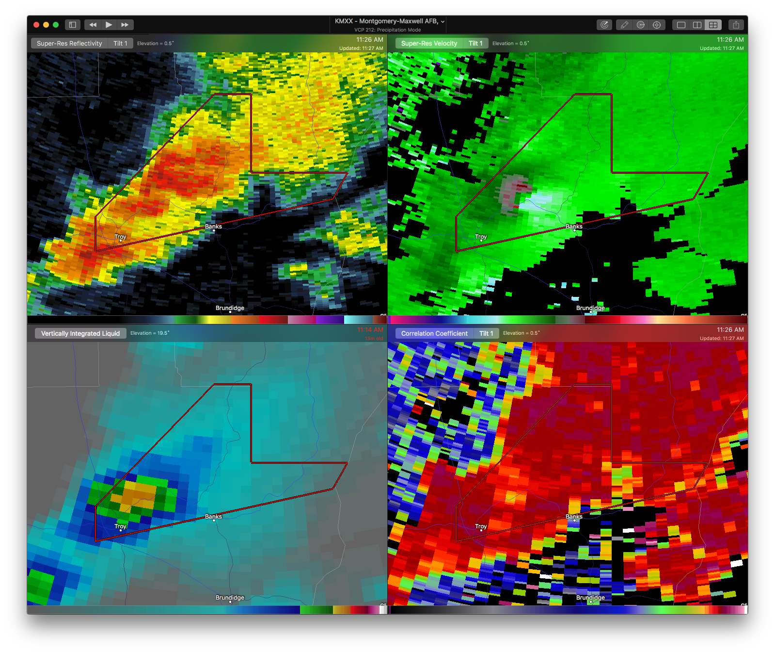

…A TORNADO WARNING REMAINS IN EFFECT UNTIL 1145 AM CDT FOR NORTHEASTERN PIKE COUNTY… At 1126 AM CDT, a severe thunderstorm capable of producing a tornado was located near Troy University, or near Troy, moving northeast at 30 mph.
HAZARD…Tornado and quarter size hail.
SOURCE…Radar indicated rotation.
IMPACT…Flying debris will be dangerous to those caught without shelter. Mobile homes will be damaged or destroyed. Damage to roofs, windows, and vehicles will occur. Tree damage is likely. Locations impacted include… Troy, Sandfield and Josie.
Tornado Warning Issued For Parts Of Pike County Until 11:45AM
Apr 27th @ 11:22 am

The National Weather Service in Birmingham has issued a
* Tornado Warning for…
Central Pike County in southeastern Alabama…
* Until 1145 AM CDT
* At 1121 AM CDT, a severe thunderstorm capable of producing a tornado was located near Troy University, or near Troy, moving northeast at 30 mph.
HAZARD…Tornado and quarter size hail.
SOURCE…Radar indicated rotation.
IMPACT…Flying debris will be dangerous to those caught without shelter. Mobile homes will be damaged or destroyed.
Damage to roofs, windows, and vehicles will occur. Tree damage is likely.
* Locations impacted include…
Troy, Banks, Linwood, Troy University, Sandfield and Josie.
Category: ALL POSTS, Archived Warnings
About the Author (Author Profile)
Subscribe
If you enjoyed this article, subscribe to receive more just like it.


