Tornado Warning Canceled For Parts Of Bullock And Montgomery Counties
…THE TORNADO WARNING FOR NORTHWESTERN BULLOCK AND EASTERN MONTGOMERY COUNTIES IS CANCELLED… The storm which prompted the warning has weakened below severe limits, and no longer appears capable of producing a tornado. Therefore the warning has been cancelled. To report severe weather, contact your nearest law enforcement agency. They will relay your report to the National Weather Service Birmingham.
Tornado Warning Continues For Parts Of Bullock And Montgomery Counties Until 9:45AM
Apr 27th @ 9:09 am

…A TORNADO WARNING REMAINS IN EFFECT UNTIL 945 AM CDT FOR NORTHWESTERN BULLOCK AND EASTERN MONTGOMERY COUNTIES… At 925 AM CDT, a severe thunderstorm capable of producing a tornado was located near Hardaway, or 11 miles south of Milstead, moving northeast at 30 mph.
HAZARD…Tornado and quarter size hail.
SOURCE…Radar indicated rotation.
IMPACT…Flying debris will be dangerous to those caught without shelter. Mobile homes will be damaged or destroyed. Damage to roofs, windows, and vehicles will occur. Tree damage is likely. This tornadic thunderstorm will remain over mainly rural areas of northwestern Bullock and eastern Montgomery Counties.
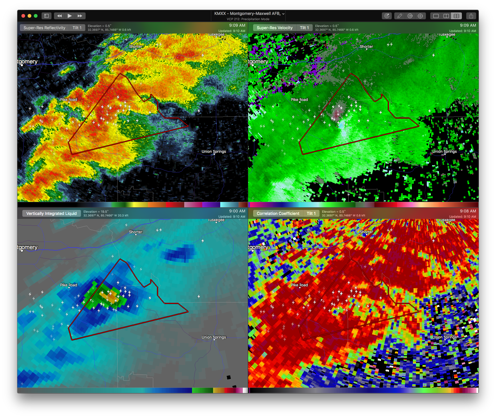
Tornado Warning Continues For Parts Of Bullock And Montgomery Counties Until 9:45AM
Apr 27th @ 9:09 am

…A TORNADO WARNING REMAINS IN EFFECT UNTIL 945 AM CDT FOR NORTHWESTERN BULLOCK AND EAST CENTRAL MONTGOMERY COUNTIES… At 912 AM CDT, a severe thunderstorm capable of producing a tornado was located 7 miles southeast of Pike Road, or 13 miles northeast of Meadville, moving northeast at 30 mph.
HAZARD…Tornado and quarter size hail.
SOURCE…Radar indicated rotation.
IMPACT…Flying debris will be dangerous to those caught without shelter. Mobile homes will be damaged or destroyed. Damage to roofs, windows, and vehicles will occur. Tree damage is likely. Locations impacted include… Mitchell.
Tornado Warning Issued For Parts Of Bullock And Montgomery Counties Until 9:45AM
Apr 27th @ 9:09 am

The National Weather Service in Birmingham has issued a
* Tornado Warning for…
Northwestern Bullock County in southeastern Alabama…
East central Montgomery County in south central Alabama…
* Until 945 AM CDT
* At 908 AM CDT, a severe thunderstorm capable of producing a tornado was located near Pike Road, or 11 miles northeast of Meadville, moving northeast at 30 mph.
HAZARD…Tornado and quarter size hail.
SOURCE…Radar indicated rotation.
IMPACT…Flying debris will be dangerous to those caught without shelter. Mobile homes will be damaged or destroyed.
Damage to roofs, windows, and vehicles will occur. Tree damage is likely.
* Locations impacted include…
Mitchell, Cecil and Carters Hill.
Category: ALL POSTS, Archived Warnings
About the Author (Author Profile)
Subscribe
If you enjoyed this article, subscribe to receive more just like it.


