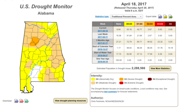
Drought Conditions Actually Increased Over The Past 7 Days
Over the past 7 days, we have seen a little increase in the drought conditions across Central Alabama, due to the limited amount of rainfall. Only some spotty to generally light rainfall occurred over parts of Central Alabama from isolated and scattered showers and thunderstorms. Most of that rainfall occurred over the northern and western parts of the area, and amounted to less than 1/2 inch.
At this point, most of the area is in abnormally dry up to moderate drought conditions, with a small area including parts of Walker, Jefferson, Tuscaloosa, and Fayette counties in severe drought conditions.
Latest USGS stream flow readings are showing that the flows are in a state of decline due to the lack of rainfall, and most streams are already below normal for this time of the year.
Here are a few totals from across the area…
Birmingham
19.32″ (2017) … 17.43″ (avg) … 1.89″ surplus … 11.52″ deficit since 1/1/16
Montgomery
19.86″ (2017) … 18.66″ (avg) … 1.20″ surplus … 10.37″ deficit since 1/1/16
Anniston
19.26″ (2017) … 17.19″ (avg) … 2.07″ surplus … 15.47″ deficit since 1/1/16
Tuscaloosa
20.60″ (2017) … 17.95″ (avg) … 2.65″ surplus … 12.44″ deficit since 1/1/16
Calera
19.83″ (2017) … 18.07″ (avg) … 1.76″ surplus … 15.53″ deficit since 1/1/16
Troy
22.66″ (2017) … 18.09″ (avg) … 4.57″ surplus … 9.76″ deficit since 1/1/16
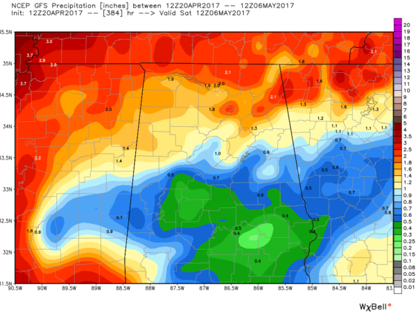
The outlook for rainfall for the next 16 days is not too great as we’ll be entering into a less active weather pattern (according to the GFS). Most locations in the area will receive less than 1 inch of rain, especially south of the I-20 corridor. North of that, some totals could reach up to 1.8 inches to 2 inches. Let’s hope that the GFS is underplaying the weather and we get more than that. We need the rain.


