Terrible Tuesday: April 10, 1979

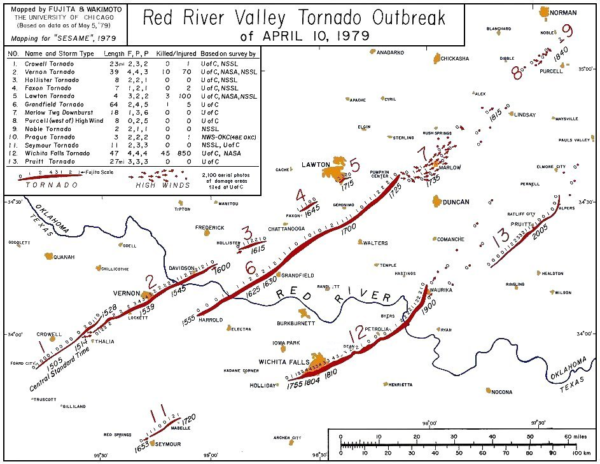
At this hour thirty eight years ago, the Red River Valley of North Texas and southern Oklahoma was under siege. The outbreak of 30 tornadoes, including three isolated supercells that produced long track, killer tornadoes was a nightmare for weather forecasters and public officials. Despite good advance notice and warnings, the death toll was high.
The morning started like many other spring mornings in Tornado Alley, but the signs were there that severe weather was likely that day. An upper level disturbance was over the western United States with a strong jet stream at 200 millibars (about 34,000 feet) extending from the Pacific across Mexico and into South Texas. The forecaster at the National Severe Storms Forecast Center in Kansas City issued his convective outlook at 2:30 on the morning of April 10, 1979, calling for a few severe thunderstorms.
At 5 a.m., the strong surface low was straddling the Wyoming/Colorado border. A warm front was south of the Red River, waiting to come northward. Across the Red River Valley, it was 54F at Wichita Falls with a dewpoint of 50F. Lawton had a temperature of 53F with a dewpoint of 48F. Not exactly tornado weather, but the location of the low to the northeast was resulting in strong southeasterly surface winds across the area. Those backed winds would play a role later. The upper trough was becoming negatively tilted, which forecasters knew spelled an enhanced severe weather threat.
By noon, satellite imagery showed a jetmax over West Texas and the warm front had moved north of the Red River, pushing dewpoints into the upper 50s by early afternoon. The National Severe Storms Forecast Center issued tornado watch number 67 at 1:55 p.m. CST for North Central Texas and Southwest Oklahoma.
This started a series of actions across the alert area. Spotter networks were put on alert and operations reported to the National Weather Service Offices in Wichita Falls and Oklahoma City. In Wichita Falls, spotters were deployed and sent to locations southwest of the city. The emergency hotline between the Wester Service Office and media and governmental officials was activity.
In Vernon, a mass of thick, dark, low clouds moved menacingly toward the city shortly before 3:30 p.m. The Texas Highway Department and Vernon Police reported a tornado on the Pease River at 3:28 p.m. A tornado warning was immediately issued for Wilbarger County and the sirens sounded in Vernon. The tornado passed across the southern edge of the city, damaging over 100 homes, killing 11 and injuring 60.
This same thunderstorm would spawn a tornado just after 5 p.m. that would bring a devastating blow to the City of Lawton, Oklahoma. Lawton was as ready as a town could be by 1979 standards. Based on spotter and radar reports, the sirens were sounded well in advance of the tornado. At 4:15, a tornado warning was issued for Comanche County, where Lawton is located, based on radar indications of 2 possible tornadoes. The warning was widely covered by radio and television and sirens were sounded. A new warning was issued at 5 p.m. About 5:05 p.m., the tornado struck Lawton. Three people died in Lawton and 100 were injured, with over 200 structures destroyed or heavily damaged.
New development began around 3:50 p.m. south of Vernon. A tornado warning was issued at 4 p.m. for Wichita County. Members of the Amateur Radio Club reported to the Wichita Falls Weather Service Office. By 4:12 p.m., damage was reported at Harrold. This activity was all northwest of Wichita Falls.
A new tornado warning was issued at 4:40 p.m. for Wichita County. A new sighting prompted a new tornado warning for Wichita County at 5:08 p.m. that was valid until 6 p.m. Sirens blew in Wichita Falls at 5:25 p.m. for the first time. More tornado sighting occurred over the next half hour and the warning was continued at 6 p.m.

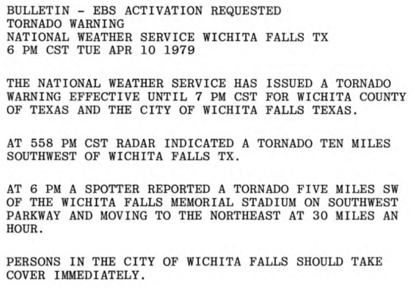
Even as that warning was being written, spotters reported a tornado southwest of Wichita Falls Memorial Stadium. The warning urged persons in Wichita Falls to take cover immediately. At 6:11 power failed at the Weather Service Office. The radar continued to run on generator, but other communications besides telephone were lost.
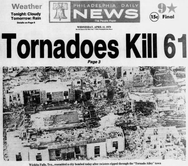
Within 30 minutes, the giant tornado had torn a gash eight miles long and between 1/2 and 1 1/2 miles wide across southern portions of the city of Wichita Falls. Forty two people were killed and three died of heart attacks. Twenty five of the deaths were in automobiles. Sixteen of those were people trying to flee the tornado. Eleven of the sixteen people’s homes were not even touched by the tornado.
The three isolated supercells produced three giant tornadoes that were on the ground for over 1 hour and for over 35 miles.

When it was all said and done, 56 people had died and 1,916 were injured. Nearly eight thousand families were affected. Nearly 20,000 people were estimated to have been displaced by the tornado in Wichita Falls alone.
TERRIBLE TUESDAY DOCUMENTARY
This video documentary was originally produced by NOAA, The American Red Cross, and FEMA around 1980. It focuses on the Wichita Falls, TX tornado of 1979, but also features Al Moller and a lot of neat preparedness footage from back then.Now, it is available online in 3 parts. If you only have time for one video, watch Part 3. Interesting SKYWARN audio. (Click the links below the picture for the video.)
Category: ALL POSTS, Met 101/Weather History


