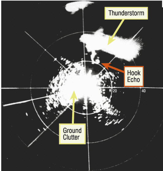
Today in Weather History: Discovery of the Hook Echo
On April 9, 1953, Glenn Stout, head of meteorology and Don Staggs, a technician at the Illinois State Water Survey in Champaign, IL were testing a re-built weather radar unit. The radar was located at Willard Airport, south of Champaign IL, and was being used along with a rain gauge network to relate radar signals with rain rates.
Staggs, the radar engineer, had stayed late to complete repairs on the radar. While testing the repairs, Staggs noticed an interesting radar return. As Stout and other associates studied the thunderstorm, they noticed how the radar echo had taken on an unusual shape. It appeared to develop a tail, that resembled a hook. He began recording the radar scope using the mounted 35 mm camera. As a result, he captured a well-defined hook echo on film.
They would learn later that at the time the “hook echo” developed, the thunderstorm was producing a tornado. Later analysis of the film taken during the test revealed that the hook shaped echo was closely associated with the tornado.
Afterwards, researchers related this information to damage and photos along the tornado’s path. It was hypothesized that the hook was associated with the tornado that the thunderstorm produced.
Analysis of radar film from the tornado that devastated Waco, TX on May 11, 1953, and the deadly Worcester, MA tornado on June 9, 1953, both indicated the same hook formation. It became apparent that tornadoes did display a unique echo and that communities could be warned when the echo appeared.
This was a major turning point in monitoring severe weather, demonstrating that tornadoes could be identified by radar. Radar indications of hook echoes would become one of the most important tools of meteorologists in issuing tornado warnings.
This discovery helped lead to the first national weather radar network in the United States known as the WSR-57 radar network.
Category: ALL POSTS, Met 101/Weather History


