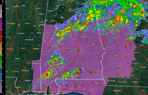
A Very Unstable Airmass Over the Southern Half of Alabama
It has been a busy morning so far, as we expected, with a surge of very moist, unstable air coming out of the Gulf of Mexico ahead of our incoming storm system.

Rain and thunderstorms continue at this hour generally in the I-20/59 Corridor. They currently aren’t severe; just lots of heavy rain, frequent lightning and loud thunder.
There is large warm sector south of the area of rain and storms. Montgomery is currently showing a temperature of 77F with a dewpoint of 68F. That is extremely juicy. Instability of at least 500 joules extends as far north as the I-20 Corridor. It increases quickly the further south you go to around 2000 joules near Clanton and 2500 joules around Montgomery.
Thunderstorms from Bibb down through Hale and Perry Counties are going to start intensifying as they push northeast into Shelby, Chilton and Autauga will be under the gun as these storms move northeast. Helicity values are not extremely high, around 150 m2/s2, but they are probably sufficient to produce an isolated tornado.
The composite parameters in this airmass south of the rain area are getting impressive. The Significant Tornado Parameter is at least 1 over the entire state south of I-20.
Storms over Southwest and South Alabama pose a significant threat, as they are isolated and are developing into supercells. There is plenty of bulk shear to support that.
We will have to watch this area across South Central and South Alabama for the next couple of hours. A tornado warning was just issued for Covington County.
The scary thing is that the Maxwell and Fort Rucker radars are out of service. Storm spotters will be vitally important today.
Scott will have an update on the latest model data shortly.
Category: Alabama's Weather, ALL POSTS


