Dangerous Severe Weather Threat Tomorrow
CALM BEFORE THE STORM: As expected, this has been a beautiful spring across the great state of Alabama; with ample sunshine temperatures are in the low 80s. Nothing on radar. Clouds will move in tonight, and showers and storms will likely arrive in the 4:00-6:00 a.m. time frame tomorrow.
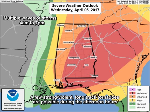
SPC has the standard “slight risk” of severe storms up for much of Central and South Alabama early tomorrow morning; the main issue for places like Birmingham, Tuscaloosa, Anniston, and Gadsden will involve hail and strong gusty winds. The primary tornado threat early tomorrow morning (before 7a CT) will be over far Southwest Alabama, where there will be some surface based instability available.
TOMORROW’S SEVERE WEATHER THREAT: The large scale features certainly will support a severe weather day in Alabama. A surface low will be southeast of St. Louis, supported by a deep upper trough with strong wind fields. Forecast surface based CAPE values (instability) are expected to soar into the 3,000-4,000 j/kg range, making for a “powder keg” situation by afternoon.
SPC has much of the state now in a “moderate” or “enhanced” severe weather risk…
Don’t get too caught up in looking at these risk maps and the associated lines, colors, and verbiage. This is simply a guideline; storms don’t read these maps and certainly don’t know where the lines are. Just understand all of Alabama will have a significant severe weather risk tomorrow.
TIMING/THREATS: There will be multiple waves of storms from 4:00 a.m. until 7:00 p.m. The primary threat with the morning storms, as discussed above, will come from hail and strong, gusty winds. Storms during the midday, afternoon, and evening hours will be capable of producing large hail, damaging straight line winds, and tornadoes. A few strong/violent, long track tornadoes are possible, especially over the central and eastern counties of Alabama.
For Birmingham and Tuscaloosa, the risk of severe storms should be over by 5:00 p.m…. and the storms should be out of the northern half of the state by 7:00 p.m. Storms could linger down across Southeast Alabama through 9:00 p.m.
RAIN: Amounts around 1 inch are likely; no flooding issues are expected.
CALL TO ACTION: Be sure you have a way of getting warnings; a NOAA Weather Radio is the baseline, and a good smart phone app is the other tier. Identify the safe place in your home, and be sure everyone knows where it is. And, in that safe place have helmets for everyone, along with hard sole shoes and preferably a portable airhorn in case you need help.
Be sure you have the ABC 33/40 app on your phone so you can watch our live severe weather coverage, if needed:
WILL THIS BE LIKE APRIL 27, 2011? I don’t like the question. April 27, 2011 was a generational event; they tend to happen once every 40 years or so. Just understand if there is only one tornado in the entire state, and if comes down your street, then it’s your April 27th.
TAKE A DEEP BREATH: This is the core of the spring tornado season in Alabama, and these kind of threats are fairly common. Nothing really unusual. We have had a very quiet five year period, and we all knew it couldn’t stay quiet forever… just have a way of hearing warnings, have an action plan, and have a good readiness kit in that safe place and we will be just fine. And, there is always the chance this could be a “bust”… a situation with storms not as severe as expected. It takes many things coming together at a single place and time for severe storms to form.
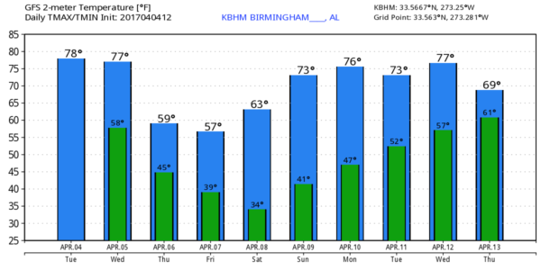
COLDER AIR: Thursday will be breezy and much cooler with gradual clearing; some lingering light rain or drizzle is possible Thursday morning over the northeast corner of the state. Temperatures Thursday will hold in the cool 50s much of the day. Then, we drop into the 37-40 degree range by daybreak Friday. Friday will be sunny and cool with a high in the low 60s.
Coldest morning will come early Saturday, when mid 30s are likely with lots of frost. Colder spots have a good chance of going below freezing.
THE WEEKEND: Expect a bright sunny sky Saturday and Sunday with a warming trend; the high Saturday will be in the upper 60s, followed by mid 70s Sunday.
NEXT WEEK: Medium range model data suggests we might see some rain back in here Tuesday or Wednesday of next week, but for now it doesn’t look like a setup for severe thunderstorms as the “wave train” takes a break for a while. See the Weather Xtreme video for maps, graphics, and more details.
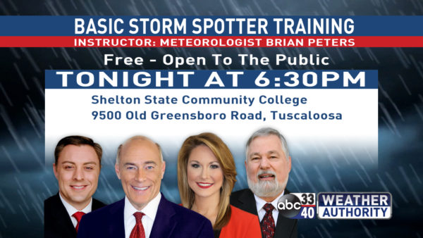
SPOTTER TRAINING IS TONIGHT IN TUSCALOOSA: It begins at 6:30 at Shelton State… we need more trained spotters… please come help us make the warning process better. No need to register, just show up!
Click here to see the Beach Forecast Center page. Save Up To 25% on Spring Break Beach Vacations on the Alabama Gulf Coast with Brett/Robinson! The Beach Forecast is partially underwritten by the support of Brett/Robinson Vacation Rentals in Gulf Shores and Orange Beach. Click here to see Brett/Robinson’s best beach offers now!.
WEATHER BRAINS: Don’t forget you can listen to our weekly 90 minute netcast anytime on the web, or on iTunes. This is the show all about weather featuring many familiar voices, including our meteorologists here at ABC 33/40.
CONNECT: You can find me on all of the major social networks…
Facebook
Twitter
Google Plus
Instagram
Pinterest
Snapchat: spannwx
I enjoyed seeing the fifth graders today at McAdory Elementary School… be looking for them on the Pepsi KIDCAM on ABC 33/40 News at 5:00 this afternoon! Stay tuned to the blog for frequent updates over the next 24 hours!
Category: Alabama's Weather, ALL POSTS


Comments (24)
Trackback URL | Comments RSS Feed
Sites That Link to this Post