Showers Early Tomorrow; More Rain Saturday Night
ACTIVE MARCH PATTERN: This is the month where anything goes, and we will have a series of big weather changes through next week. Today should be the nicest day out of the next seven… while we are cold this morning (Fort Payne has dropped to freezing), we warm quickly, and most places will enjoy a high in the mid 70s this afternoon.
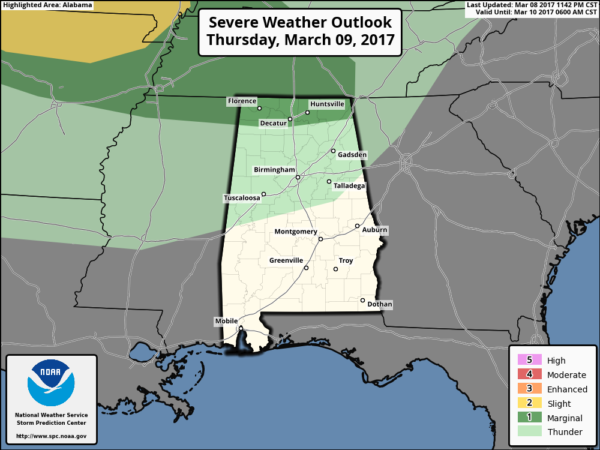
TONIGHT/TOMORROW: Clouds move in tonight ahead of a cold front, and a band of showers and storms will pass through North and Central Alabama early tomorrow morning. SPC has even put far North Alabama in a “marginal” severe weather risk for the pre-dawn hours tomorrow… some of the heavier storms could produce strong gusty winds and some small hail.
The main window for showers and storms will come from 2:00 until 8:00 a.m. Rain amounts should be fairly light, and the sky should clear with a good chance of sunshine through the midday and afternoon hours tomorrow. It will be cooler with highs back in the 60s.
THE ALABAMA WEEKEND: A wave of low pressure forms west of Alabama, and clouds move back into the state Saturday, and we will deal with widespread rain Saturday night. For now it looks like the main chance of rain will come from 4:00 p.m. Saturday through 8:00 a.m. Sunday. The air will be cool and stable (temperatures will be in the 40s when the rain falls Saturday night), so there is no chance of severe weather, and rain amounts will be in the 1/2 to 1 inch range.
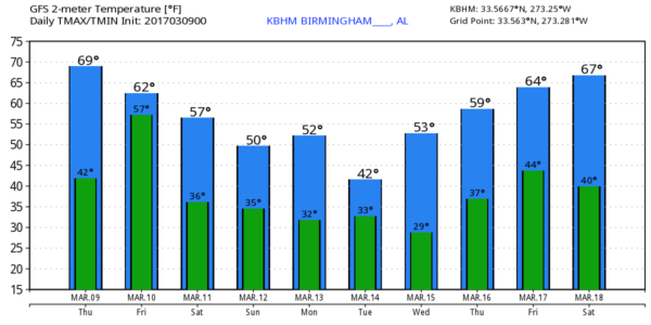
Prior to the rain, the high Saturday will be in the 57-60 degree range as cooler air slips in from the north. Then, after the rain Sunday, even colder air arrives… and many communities won’t get out of the 40s with a chilly north wind.
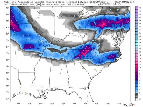
TO THE NORTH: Snow is likely in the colder air over Tennessee Saturday night; some accumulation is possible, generally in the 1-2″ range. And, yes, some snow/sleet/freezing rain could creep southward into extreme North Alabama early Sunday morning. With a warm ground, I would say the chance of accumulation over the Tennessee Valley is small… although a dusting is possible across higher elevations. Overall, for now a big impact in the North Alabama counties is not expected.
NEXT WEEK: The first half of the week will feature temperatures well below average. A clipper will pull down a new surge of cold air Tuesday, and we might even see a few snow flurries over the northern quarter of the state Monday night and Tuesday morning, but no impact is expected. The high Tuesday will be in the 40s, and there is a good chance we see lows down in the 20s early Wednesday morning. We will have a warming trend Thursday and Friday, and some rain is possible before the week is over. See the Weather Xtreme video for maps, graphics, and more details.
Click here to see the Beach Forecast Center page. Save Up To 25% on Spring Break Beach Vacations on the Alabama Gulf Coast with Brett/Robinson! The Beach Forecast is partially underwritten by the support of Brett/Robinson Vacation Rentals in Gulf Shores and Orange Beach. Click here to see Brett/Robinson’s best beach offers now!.
WEATHER BRAINS: Don’t forget you can listen to our weekly 90 minute netcast anytime on the web, or on iTunes. This is the show all about weather featuring many familiar voices, including our meteorologists here at ABC 33/40.
CONNECT: You can find me on all of the major social networks…
Facebook
Twitter
Google Plus
Instagram
Pinterest
Snapchat: spannwx
I have a weather program this morning at Fayette Christian Academy… look for the next Weather Xtreme video here by 4:00 this afternoon. Enjoy the day!
Category: Alabama's Weather, ALL POSTS


