Fabulous March Weekend
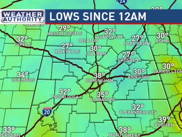
BRRRRRRRR!!!! It is definitely one chilly morning for Central Alabama with lows dropping into the 20s in many locations. Noccalula Falls reported 26 this morning, Black Creek was 23, and my station in Helena seems to have stopped falling at 32. Could this be the last freeze of the season? Probably not just yet. The average date of the last freeze since 1900 is March 25th plus the longer range forecasts still could mean some chilly mornings yet. Sunshine will be plentiful today with highs climbing into the lower and middle 60s.
Weather also looks good for any beachgoers. Sunny weather today will see a high around 68. Clouds increase for Sunday with widely scattered showers returning Monday as highs climb back into the 70s. For a detailed look at the weather from Fort Morgan to Panama City Beach, click here to see our Beach Forecast Center page. Save Up To 25% on Spring Break Beach Vacations on the Alabama Gulf Coast with Brett/Robinson! The Beach Forecast is partially underwritten by the support of Brett/Robinson Vacation Rentals in Gulf Shores and Orange Beach. Click here to see Brett/Robinson’s best beach offers now!.
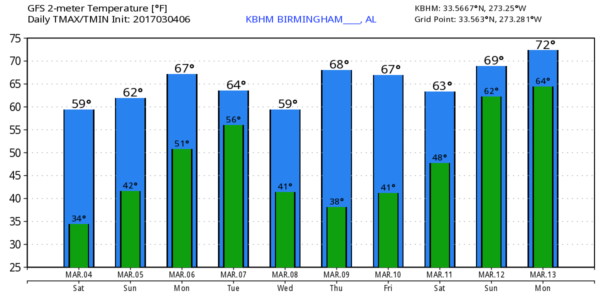
The flow aloft goes into a nice ridge for Sunday as temperatures continue to climb. The morning won’t be quite as cold with lows in the middle and upper 30s with most locations heading for highs in the middle and upper 60s.
Surface flow west of us on Sunday takes on a decidedly southerly component with showers a good possibility west of us on Sunday and Monday. Showers will edge close to Alabama on Monday, but I think most of us stay dry for the day.
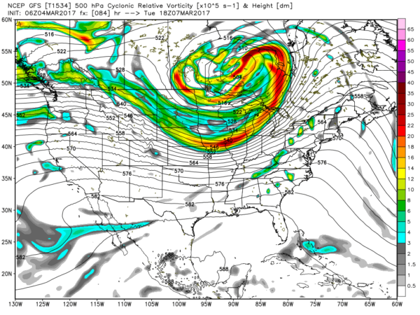
A whopper of an upper closed low moves across southern Canada on Tuesday dragging a cold front through the Lower Mississippi River. The major dynamics with this system will be well north of us, so the threat of severe weather is not enough to actually identify a risk area. The GFS suggests that dew points into the lower 60s will surge northward all the way to the Tennessee River Valley, so we’ll need to keep an eye on future runs. The front blasts through the Southeast late Tuesday and early Wednesday dropping temperatures across the area once again. Looks like low will get back into the 30s but not nearly as cold as this morning while highs fall back into the 60s.
The upper flow remains northwesterly on Thursday and evolves into an upper ridge by Friday. A weak short wave trough in the flow on Saturday could produce some scattered showers by Saturday as highs move to near 70.
The flow remains active as we look into voodoo country. A short wave trough passing through the southern Great Lakes will bring another front to the area around the 13th of March. There is a very strong upper closed low forecast to move through the Mississippi River Valley around the 15th of March. Much too far out to make any specific forecasts, but the overall look of this pattern has severe weather written all over it. And by the end of the period around the 18th of March it looks like another respectable chill down with freezing temperatures once again possible.
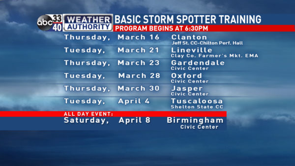
I expect to have the next post hear on Sunday morning by 7 or so. Don’t forget to mark your calendar for severe storm spotter training in March and early April. The full schedule is shown in the graphic below. Enjoy the fabulous March day and Godspeed!
-Brian-
Category: Alabama's Weather, ALL POSTS


