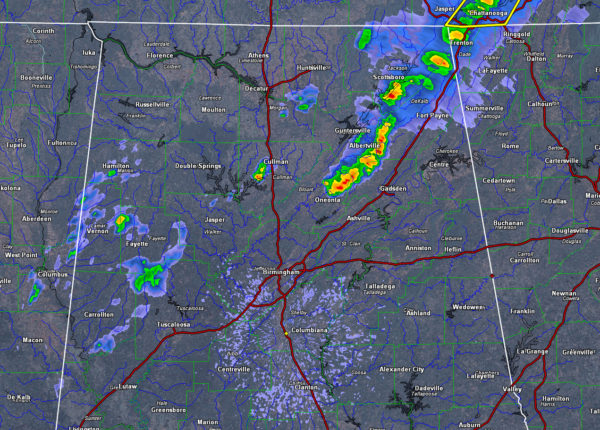
Storms Limited to Northeast Alabama Now; Elsewhere, Showers Slowly Weaken Overnight; Much Cooler Today

Thunderstorms are moving into Etowah County as we approach 1 a.m. early on this Saturday morning. They will coninue into DeKalb and Cherokee Counties as they slowly weaken.
Showers over West Central Alabama ahead of a cold front are weakening also. They are over parts of Marion Lamar, Fayette, Pickens and Tuscaloosa Counties.
They will continue east northeast overnight and slowly continue to weaken.
By early morning, temperatures will be in the lower 40s over Northwest Alabama, near 50F in the I-59 Corridor and in the lower and middle 50s to the southeast.
Temperatures later today will have a hard time going very far, with the strong cold air advection, despite a good supply of sunshine. You will notice the biting northwest wind all day as well, averaging some 10-20 mph with gusts to over 25 mph at times. Highs today will struggle to rise into the middle and upper 50s.
FREEZE SATURDAY NIGHT: Lows tonight will be chilly, with lows along and north of I-20 ranging between 27-32F. Between I-20 and I-85, lows will range from 32F to 37F. After today’s warmth, that will feel quite chilly.
SUNNY SUNDAY: Sunday will be a mostly sunny day, but temperatures will struggle to reach 60F. Winds will become southeasterly Sunday night, allowing for some warmer temperatures. Lows by Monday morning will be in the lower 40s generally.
ROLLER COASTER CONTINUES: By Sunday night, a powerful jet stream will still be blowing across the southern United States. Those southerly surface winds, circulating around high pressure to the east of North Carolina, will be pumping in some deep moisture as well as warmth.
Rain will increase in coverage through the day and into Monday night. There could be some thunder by afternoon and into the overnight hours. Rainfall amounts could be decent between one and two inches through noon Tuesday.
Temperatures on Monday will be held down by the rain and clouds and will likely be limited to the 50s and lower 60s.
Tuesday will find us in the warm sector and highs may soar well into the 70s. If this happens there could be decent instability for strong to severe thunderstorms. We will be watching.
Category: Alabama's Weather


