Record Warmth Today; A Freeze Early Sunday
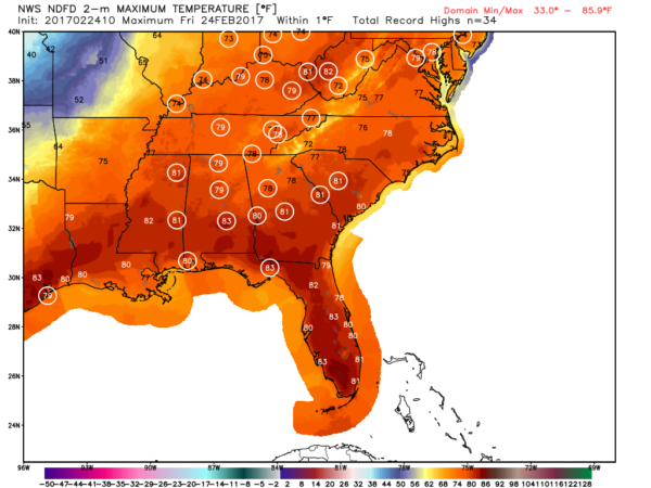
WARM LATE WINTER DAY: A cold front will blow into Alabama after midnight tonight, but prior to its arrival today will be very warm for late February with record warmth likely. Most communities will see a high between 77 and 80 degrees this afternoon over the northern half of the state, and Birmingham’s record high for February 24, 78 set in 1930, is very much in danger. The sky will be partly to mostly sunny.
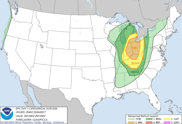
Up north, blizzard warnings remain in effect for parts of Iowa and Minnesota in the cold sector of a storm system moving through the Midwest. South and east of the surface low, in the warm air, severe storms are likely over part of Indiana, Michigan, Ohio, and Kentucky where an “enhanced” severe weather risk has been defined by SPC.
A “marginal” risk clips the northeast corner of Alabama tonight for storms that fire up along the cold front; forecast instability values, moisture levels, and wind fields suggest the overall severe weather threat for our state is pretty low, despite the big temperature drop coming. The main threat for showers and storms ahead of the front will come from about 11:00 p.m. until 3:00 a.m.
WEEKEND COOL DOWN: Temperatures will drop about 20 degrees tomorrow; the high will be in the upper 50s despite sunshine in full supply, and a stiff northwest breeze will make it feel colder. A freeze is likely by early Sunday morning with most communities seeing a low between 28 and 32 degrees. Sunday will be another cool, dry day with ample sunshine and a high close to 60 degrees.
NEXT WEEK: The first half of the week will be wet and stormy at times. Periods of rain are likely Monday; for now it looks like a warm front will be a little south of here, meaning the rain will fall in a cool, stable airmass. The warm front lifts northward Monday night, and we should see a few thunderstorms Tuesday, Tuesday night, and into Wednesday morning ahead of the next cold front. Some strong storms are certainly possible in that time frame, but it remains to be seen if a severe weather threat will develop. Cooler, drier air returns for Thursday and Friday. Another late season freeze is very possible by Friday March 3 or Saturday March 4. See the Weather Xtreme video for maps, graphics, and more details.
Click here to see the Beach Forecast Center page. Save Up To 25% on Spring Break Beach Vacations on the Alabama Gulf Coast with Brett/Robinson! The Beach Forecast is partially underwritten by the support of Brett/Robinson Vacation Rentals in Gulf Shores and Orange Beach. Click here to see Brett/Robinson’s best beach offers now!.
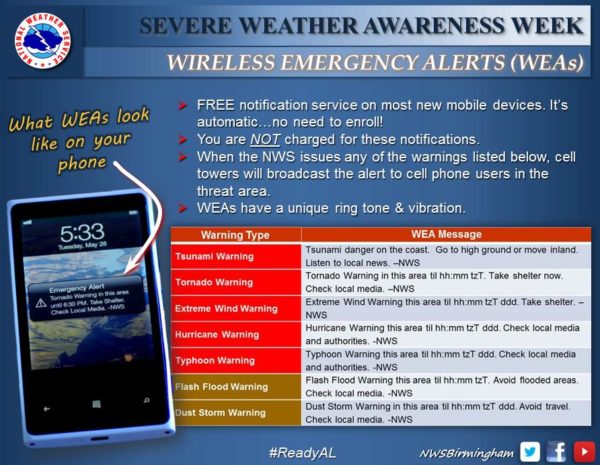
SEVRE WEATHER AWARNESS WEEK: It wraps up today, and the reminder is to be sure you have a good way of hearing watches and warnings. Every Alabama home should have a NOAA Weather Radio, and have a good warning app on your smart phone. Most new phones do come equipped with WEA (Wireless Emergency Alerts) enabled…
WEATHER BRAINS: Don’t forget you can listen to our weekly 90 minute netcast anytime on the web, or on iTunes. This is the show all about weather featuring many familiar voices, including our meteorologists here at ABC 33/40.
CONNECT: You can find me on all of the major social networks…
Facebook
Twitter
Google Plus
Instagram
Pinterest
Snapchat: spannwx
I have a weather program this morning at Lineville Elementary in Clay County… look for the next Weather Xtreme video here by 4:00 this afternoon. Enjoy the day!
Category: Alabama's Weather


