Stormy Weather Pattern Through The Weekend
ACTIVE JANUARY WEATHER: We will be dealing with multiple rounds of rain and storms across Alabama through the weekend, with some potential for severe weather along the way.
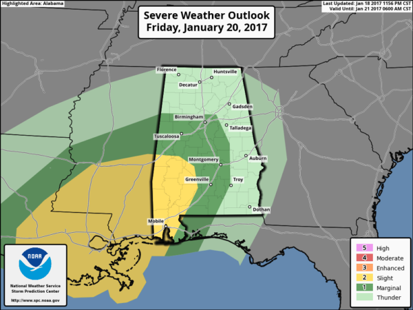
TODAY/TONIGHT: SPC has parts of Central and South Alabama in a “marginal” risk for severe storms over the next 24 hours…
Rain is already falling over parts of the state this morning, and as an upper trough gets closer, rain and storms will be more widespread this afternoon and tonight. With this widespread rain, instability values will be limited, and with forecast soundings looking rather saturated, the overall severe weather threat seems pretty limited.
TIMING: Main window for the stronger storms will come from 3:00 this afternoon through about 12:00 midnight.
THREATS: Some of the heavier storms could produce gusty winds and small hail. The chance of a small tornado is pretty small, but not zero.
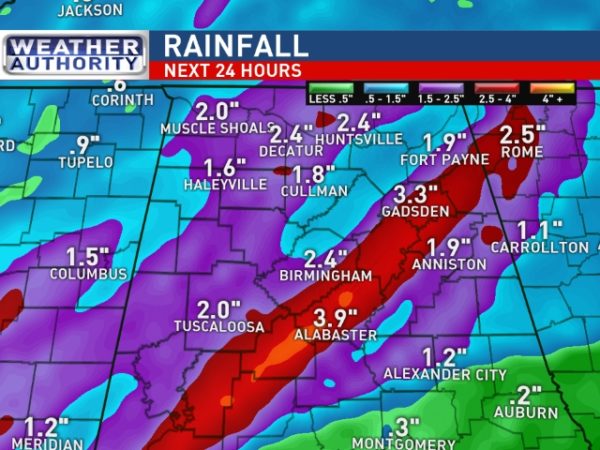
RAIN: Data from the RPM model suggests we could very well see some spots getting over 2 inches of rain over the next 24 hours, and if this verifies we could very well have some localized flash flooding problems. This looks to be more of a heavy rain event as opposed to a severe weather event.
Be sure you can hear severe weather warnings in the event they are needed later today and tonight.
TOMORROW AND THE WEEKEND: A complex severe weather pattern is setting up for Alabama, and we really need to get past the round of storms today and tonight before we can really be confident on forecasting timing of the various rounds of storms, and the overall magnitude of the event.
A deep upper trough with strong wind fields will approach from the west, and with high instability values, deep layer shear, and steep lapse rates, we will all have to pay close attention to the weather late tomorrow through Sunday morning. This is the current thinking on the timing…
ROUND ONE: The first round of severe storms is possible from about 9:00 p.m. tomorrow through 9:00 a.m. Saturday, generally over the southern half of the state. SPC has Southwest Alabama in the standard “slight risk”, with a “marginal risk” up to Tuscaloosa and Birmingham…
ROUND TWO: The air becomes very unstable by Saturday afternoon, and a few scattered severe storms are possible from about 2:00 p.m. until 8:00 p.m. Saturday over the state, including North Alabama. This round is a little “iffy” with the best dynamics a little to the west; much will depend on how the “round one” event impacts the airmass over the state.
ROUND THREE: A final round is likely from about 12:00 midnight Saturday night through 9:00 a.m. Sunday; this is when the best dynamic forcing will be in place.
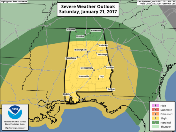
SPC has most of Alabama in the standard “slight risk” for Saturday, Saturday night, and early Sunday morning (the Day 3 outlook runs from 6:00 a.m. Saturday to 6:00 a.m. Sunday)…
All modes of severe weather will be possible with the weekend storms, including damaging straight line winds, hail, and tornadoes. We will be much more specific about the threat tomorrow morning, but just understand you will need to pay close attention to the weather over the weekend.
NEXT WEEK: Monday will be windy and cooler with clouds and some lingering light rain; the high will drop into the 50s. And, even colder air arrives later in the week with highs dropping into the 40s. See the Weather Xtreme video for maps, graphics, and more details.
As always, watch me for the full weather story on ABC 33/40 News this evening at 4, 5, 6, and 10:00!
WEATHER BRAINS: Don’t forget you can listen to our weekly 90 minute netcast anytime on the web, or on iTunes. This is the show all about weather featuring many familiar voices, including our meteorologists here at ABC 33/40.
CONNECT: You can find me on all of the major social networks…
Facebook
Twitter
Google Plus
Instagram
Snapchat: spannwx
I am in Tampa this morning for a company meeting, but will return later today. Most likely I won’t be able to produce a video this afternoon, but we will have forecast notes and running updates on the thunderstorm situation. Keep a close eye on the blog during this active weather, and enjoy the day!
Category: Alabama's Weather


