Increasing Rain Chances Later This Week
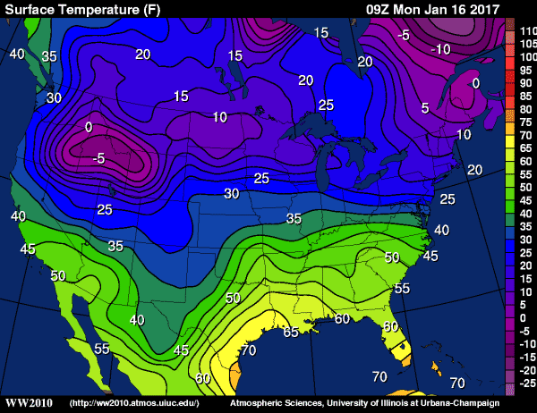
STILL WARM FOR JANUARY: An upper low lifted out of the Southwest U.S. over the weekend, and brought severe storms to parts of Texas last night, but the main energy from that feature will remain well to the west and north of Alabama today, and accordingly our weather won’t change much. A mix of sun and clouds, and a high in the low 70s this afternoon, about 20 degrees above average for January. Very cold air continues over the northern U.S… but the upper air pattern won’t allow it to move southward in the short term.
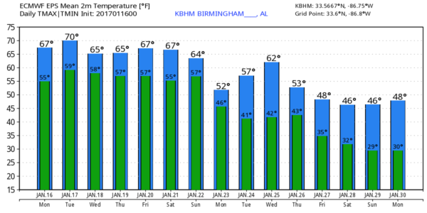
MID-WEEK: A weakening surface front will bring the chance of showers to the state tomorrow afternoon and tomorrow night, but with little dynamic support rain amounts should be on the light side, and I doubt if we hear much thunder. Slightly drier air works into the state Wednesday with generally dry conditions and only a few scattered showers. The high will drop back slightly into the mid to upper 60s Wednesday.
The next wave approaching from the west will bring more rain to Alabama Thursday afternoon and especially Thursday night; we could deal with a few strong thunderstorms with some unstable air involved, but for now the overall severe weather threat looks low.
FRIDAY: Showers and storms should end Friday morning with drier air working into the state Friday afternoon. Still warm with a high in the 70s.
THE ALABAMA WEEKEND: A rather robust system will bring rain and storms back to the state, and it looks like we could very well have a risk of severe storms Saturday night. SPC has put the southern half of the state in a severe weather risk on the “Day 6” outlook, and that will probably be pulled northward later this week as a strong upper trough will support a deepening surface low to the west of Alabama. Too early to be really specific on the threat; just something to watch for now.
On the positive side, some beneficial rain is likely over the next seven days, with potential for over three inches in many places. Keep in mind the northern half of Alabama remains in a drought.
NEXT WEEK AND BEYOND: Cooler air returns to the state next week, and evidence highs will drop into the 40s, with lows below freezing by the end of the month as the pattern flips.
See the Weather Xtreme video for maps, graphics, and more details.
WEATHER BRAINS: Don’t forget you can listen to our weekly 90 minute netcast anytime on the web, or on iTunes. This is the show all about weather featuring many familiar voices, including our meteorologists here at ABC 33/40.
CONNECT: You can find me on all of the major social networks…
Facebook
Twitter
Google Plus
Instagram
Look for the next Weather Xtreme video here by 4:00 this afternoon… enjoy the day!
Category: Alabama's Weather


