Very Cold Air By Friday; Wintry Precipitation??
TRENDING COLDER: The first surge of colder air moves into Alabama today; temperatures will hover around 50 degrees much of the day with a sky featuring more clouds than sun. No rain expected. Tomorrow will be dry and cool with a partly sunny sky and a high between 52 and 55 degrees for most places.
FRIGID FRIDAY: Things begin to get interesting Friday as true Arctic air arrives; it looks like temperatures will hover in the 30-34 degree range all day with a cloudy sky… this is some of the coldest air we have experienced so far this winter season. Very cold air is a certainty, but everybody wants to know about potential for wintry precipitation in the cold air, and that is the focus of this discussion.
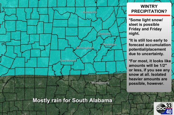
METEOROLOGICAL SETUP: Most model guidance suggests the atmosphere will be cold enough for snow over the northern half of the state during the day Friday, but with limited moisture. Seems like two separate areas of precipitation will initiate Friday; some light snow over North Alabama with an upper feature, and rain for the southern half of the state as a weak low pressure area forms in the northern Gulf of Mexico.
The most widespread precipitation will most likely come Friday night over the southern two-thirds of the state, with potential for some snow/sleet/freezing rain on the northern periphery across Central Alabama. It all ends early Saturday morning as the low lifts northeast.
There is decent agreement in the big picture, but huge model differences in the small scale details which will determine the actual weather and impact for any given point. So, I have decided to hold off on putting together an accumulation potential/placement map until this afternoon; the local weather enterprise will conference early this afternoon and do our best to give you a unified message later today.
IMPORTANT POINTS: Long time readers/viewers know I like to tell people what we know, and I don’t tell them what we don’t know. So… this is what we know this morning…
*Moisture over the northern half of the state will be pretty limited, so snow amounts, if any, will most likely be light, under 1/2 inch (if you see snow at all).
*There is some chance, we we see phasing between the two precipitation areas Friday night, a heavier strip of wintry precipitation could develop over Central Alabama, but there is no way now of knowing exactly where that happens. And, this could be more sleet and freezing rain than snow. Guidance from NOAA’s WPC hints freezing rain problems could develop Friday night along I-85 from Montgomery toward Opelika. Freezing rain is simply rain that falls with temperatures at or below 32 degrees at the surface.
*In terms of travel impact, light snow Friday morning could bring a few icy spots to North Alabama. But, the highest potential for icy travel issues should come Friday night with temperatures drop into the 20s over the northern half of the state.
*Sure, anything can happen, but this it NOT an analog to January 28, 2014 (snowmageddon). Snow was falling with temperatures near 20 degrees during that event; the ice accretion process on roads, as we have learned, is radically different with surface temperatures that cold. Temperatures will be in the 29-34 degree range Friday/Friday night. Yes, some icy travel is very possible, but it won’t be like the horrible day in January 2014.
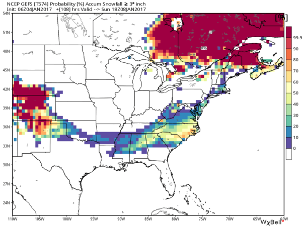
*Be sure and check the blog later today for updates… please don’t work with old information as you make plans, especially if you are traveling. And, speaking of traveling, higher probabilities of over 3 inches of snow are east of Alabama, across parts of Georgia and the Carolinas (their snow comes Saturday)…
*Watch the Weather Xtreme video for all the maps, graphics, and more details on this event!
VERY COLD WEEKEND: The sky becomes partly sunny Saturday, and Sunday will be bright and sunny, but the weather will be very cold. We won’t get out of the 30s Saturday, and the low early Sunday and Monday will be in the 17-22 degree range.
NEXT WEEK: We start to warm up Monday afternoon, and the latest global model output shows a chance of rain returning to the state Wednesday with a short wave trough approaching.
WEATHER BRAINS: Don’t forget you can listen to our weekly 90 minute netcast anytime on the web, or on iTunes. This is the show all about weather featuring many familiar voices, including our meteorologists here at ABC 33/40. Scroll down for the show notes on the new episode we recorded last night.
CONNECT: You can find me on all of the major social networks…
Facebook
Twitter
Google Plus
Instagram
Look for the next Weather Xtreme video here by 4:00 this afternoon… enjoy the day!
Category: Alabama's Weather


