Sunny Skies And Cool At Midday For The Last Friday Of 2016
The Last Sunny Day Of 2016
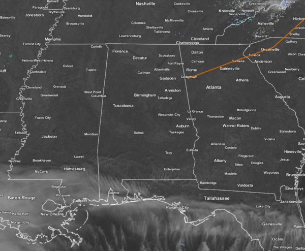
Sunny skies and cool temperatures are the main weather feature across Central Alabama at the midday hour. The only cloud cover showing up in the state is currently over Mobile and Washington counties. Hope you enjoy this last Friday of 2016 because it will be the last sunny day for the year. The New Year’s weekend looks to be cloudy and quite wet.
Temperatures Across Central Alabama
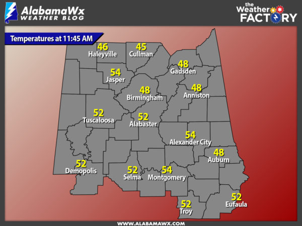
Temperatures at 11:45 AM are ranging from the mid 40s in the northern parts of the area, to the mid 50s in the south. The warm spots are currently Alexander City and Jasper at 54 degrees. The cool spot is currently Cullman at 45 degrees.
Birmingham’s Climatology And Records
The normal high for December 30th is 53, while the normal low is 33. The record high for today was set back in 1984 at 76 degrees. The record low was set back in 1917 at 8 degrees.
Weather For The Remainder Of The Day
The remainder of the afternoon will be filled with sunshine, with high temperatures only making it into the upper 40s to mid 50s across the area from the northeast to the southwest. Winds will once again be out of the northwest at 5-10 MPH, and that will make wind chill temperatures feel 3 to 6 degrees cooler than the actual temperature. Skies will be mostly clear to start off the evening, but will be mostly cloudy by daybreak. Overnight lows will be in the upper 20s to the mid 30s. Winds will become calm at sunset then start to average 1-5 MPH out of the south after midnight.
The New Years Eve Forecast
Saturday will start off dry, but clouds and rain chances will rapidly increase through the day from the south and west. There is a possibility that there may be a few ice pellets or a stray snowflurry or two as the moisture first moves into our dry airmass and evaporative cooling takes place, but temperatures will be above freezing and there will be no impact. Afternoon highs will be in the mid 40s in the northeast to the mid 50s to the southwest. Rainfall will become likely, and temperatures will warm during the evening and overnight hours. Temperatures will be coolest around 6:00 PM in the mid 40s to low 50s across the area, but will be in the low to upper 50s by daybreak.
Latest On Our Drought Situation
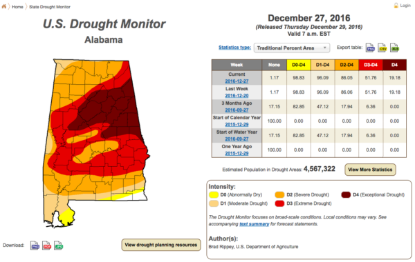
The latest U.S. Drought Monitor continues to indicate extreme to exceptional drought conditions persist across much of Central Alabama. There is no change in the percentage numbers for the drought conditions for this week compared to last week. Over 86% of the state remains defined in severe drought conditions, over 51% of the state defined in extreme drought conditions, and over 19% of the state defined in exceptional drought conditions. Only the extreme southeastern parts of the state (parts of Geneva and Houston counties) are out of any drought definition. Here is a list of cities and their current rainfall totals for 2016 and their deficits:
- Birmingham 39.83 in (-13.50 in)
- Montgomery 40.89 in (-11.76 in)
- Anniston 31.39 in (-17.92 in)
- Tuscaloosa 37.05 in (-15.18 in)
- Calera 36.94 in (-17.29 in)
- Troy 39.92 in (-14.40 in)
The fire danger risk has decreased across much of the state due to rainfall over the past 30 days. While the statewide burn ban has been rescinded, there remains concern that many pine trees could still die due to the drought that has plagued the state. The state forester continues to urge people that are doing any outside burning to follow safety precautions such as not leaving any fire unattended and having the proper equipment and personnel to control the fire. Since October 1st, over 1,100 wildfires have occurred in Central Alabama, and over 20,000 acres have burned based on reports from the Alabama State Forestry Commission. At this time, there are no ongoing wildfires.
Alabama At The Peach Bowl
Alabama will be facing the Washington Huskies in the Georgia Dome on Saturday afternoon at 2:00 PM. The day looks cloudy and rain is expected to move into North Georgia during the evening hours on Saturday. High will be near 50 in Downtown Atlanta. Weather won’t impact the game since it is indoors.
Auburn At The Sugar Bowl
Auburn will be facing the Oklahoma Sooners down in New Orleans in the Super Dome on Monday evening at 7:30 PM. Weather looks rather wet and unsettled, with showers and thunderstorms likely, and temperatures in the middle 70s. Once again, weather will not impact this game as it is indoors.
Headed To The Beach
Sunny and breezy today, but cloudy skies and multiple chances of rain returns for the weekend and into the beginning of next week. See the complete Gulf Coast 7-Day Planner here..
On This Day In Weather History: 1933
The temperature reached 50 degrees below zero at Bloomfield, VT. It was the coldest reading in modern records for New England. The temperature at Pittsburgh NH reached 44 degrees below zero.
Follow The Blog On Social Media
Remember that we are also on Facebook and on Twitter.
WeatherBrains
This is the weekly netcast that’s all about weather featuring many familiar voices, including our meteorologists at ABC 33/40. You can listen anytime on the web, or on iTunes. You can find it here.
Forecaster: Scott Martin (Twitter: @scottmartinwx)
Category: Alabama's Weather


