Stormy Followed by Parade of Systems
Let’s start off with the temperature trace for the last 24 hours. The normal sine wave of lows around sunrise and highs around mid afternoon was replaced by a fairly sharp rise in temperatures yesterday morning followed by a gradual rise in temperatures from about noon yesterday through early this morning. Definitely not your typical temperature profile.
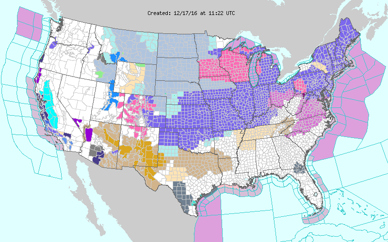
Much of the Southeast US is cloudy this morning, but additional warming is still expected to take place with highs reaching the upper 60s to lower 70s. Radar is relatively quiet with only a few patches of light rain showing up, most of which is not reaching the ground just yet with a relatively dry sounding. The storm system is also creating a really messy watch/warning/advisory map with winter weather issuances from the Texas Panhandle to New England.
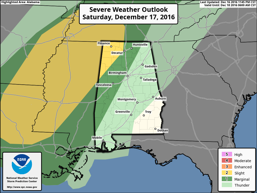
The warming is coming thanks to strong southerly flow ahead of a strong cold front and upper trough to our west. This is also setting the stage for a round of potentially severe storms with the primary slight risk area defined by SPC stretching from West Tennessee southwestward to South Central Louisiana. This is shaping up to be a relatively low CAPE/high shear situation. Initially we will need to watch for the development of isolated discrete thunderstorms with the potential for tornadoes since the wind profiles/hodographs are certainly favorable, but with time as we get into the evening hours today and early morning hours of Sunday, the overall character of the storms should evolve into a squall line – or QLCS – which would mean a fairly high risk for damaging wind along with the potential for brief tornadoes. The severity of the storms may also be hampered by the timing of the squall line as it comes through Central Alabama during the early morning hours between about midnight tonight and midmorning Sunday. Still, it is important with this timing that everyone have a way to be awakened by the weather warnings.
This round of storms should produce rainfall amounts in the range of three-quarters to one and a half inches of rain. Another round of rain on Thursday could bring additional totals around half an inch. All of this rain very beneficial to putting a bigger dent in the drought conditions.
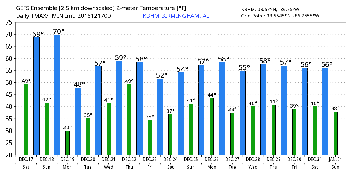
Temperature forecasts Sunday will be a bit of a challenge. With the front and squall line projected to move through in the morning hours Sunday, we should see the temperature take a sharply downward direction following the frontal passage. For much of West Central and Central Alabama I expect to see the temperature steady in the morning and fall in the afternoon. This is one of those times when the daily high is likely to come just after midnight with the daily low between 11 pm and midnight, all completely out of phase with a typical diurnal trace. For those in East Central Alabama, temperatures will likely hold longer and begin to fall with the frontal passage in the afternoon.
And as is typically the case, the cold air arrives as the moisture departs. There is a period roughly from about 6 am to noon on Sunday morning when a brief period of wintery precipitation is possible especially across the Tennessee River Valley. It appears most likely that the temperature profile will support light freezing rain. With the period for wintery precipitation so short and with ground temperatures relatively warm, I’m not expecting to see any kind of serious travel issues. What we might see is the collection of a little light icing on exposed surface like cars and other metal surfaces.

We dry out and cool off for Monday and Tuesday. Fortunately, we won’t be dramatically colder with lows in the 20s and highs in the 40s on Monday warming up a little on Tuesday with lows in the 30s and highs in the 50s.
Wednesday and Thursday we turn our attention to yet another strong upper trough comings across the Mississippi River Valley. This system promises to bring another round of rain for us, but model differences lower the confidence on just how much rain we might get. The GFS shows a stronger system and so more rain while the ECMWF is weaker with the system and shows less rain. Personally, I’m pulling for the GFS since we need the rain. High temperatures Wednesday and Thursday will be primarily in the 50s but we could see lower 60s south of Birmingham. Too far out for any specific forecasts just yet, but there may well be another potential round of severe storms with this system.
There’s another lull on Friday as we come under weak ridging aloft and a surface high centered over Kentucky and Tennessee. Friday will be fairly typical for us with lows in the 30s and highs in the 50s.
Saturday, Christmas Eve, will be another transition day as the next system in a steady parade of systems takes shape to our west. Right now it looks like the 25th and 26th of December could be pretty wet. Much too early to project anything definite, but there could be yet another bout of severe weather.
Looking further afield, the GFS is definitely bullish on a steady parade of strong weather systems. After the one on the 26th/27th, the GFS depicts another one for the 29th/30th of December and a third one in the 1st/2nd of January time frame. Absolutely no rest in the weather office with this unending parade of systems.
The meteorologists here at the blog will be keeping a close eye on developments today and tonight, so check back here often for later updates. Be sure to have a way to get weather warnings while you’re sleeping. I expect to have the next Weather Xtreme Video posted here first thing on Sunday morning, but those plans will have to be somewhat fluid due to the current weather situation. Have a great day and Godspeed.
-Brian-
Category: Alabama's Weather
About the Author (Author Profile)
Brian Peters is one of the television meteorologists at ABC3340 in Birmingham and a retired NWS Warning Coordination Meteorologist. He handles the weekend Weather Xtreme Videos and forecast discussion and is the Webmaster for the popular WeatherBrains podcast.Subscribe
If you enjoyed this article, subscribe to receive more just like it.


