Cold, Warm, Storms, Cold Again
HOP ABOARD THE ALABAMA WEATHER ROLLER COASTER: No dull moments around here through the weekend. Let’s go through this active pattern.
COLD TONIGHT: Despite sunshine in full force, temperatures are only in the 38-42 degree range across much of North Central Alabama this afternoon. This is 15-20 degrees colder than average for mid December. We drop well below freezing tonight; by daybreak tomorrow most communities will see a low between 21 and 25 degrees.
Tomorrow will be dry and warmer, with a partly sunny sky the afternoon temperature will reach the mid 50s.
SATURDAY WARMTH: We zoom into the low 70s Saturday with a strong southerly breeze and a wide open Gulf of Mexico. This is about 50 degrees warmer than the lows we are expecting early tomorrow. Showers will develop during the day Saturday as moisture levels rise; the most widespread rain Saturday should be along and north of I-20 (Tuscaloosa, Birmingham, Anniston and points north).
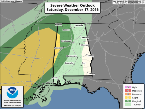
SATURDAY NIGHT STORMS: SPC maintains the standard “slight risk” of severe storms for far West Alabama late Saturday night into the pre-dawn hours Sunday, with a “marginal risk” as far east as Birmingham and I-65…
Dewpoints will surge into the 60s Saturday night, making for an unstable atmosphere. With fairly high storm relative helicity values, strong to severe storms will likely form along the approaching Arctic front. Storms could produce hail, strong gusty winds, and an isolated tornado is possible.
The main window for strong to severe storms will come from about 11:00 p.m. Saturday until 6:00 a.m. Sunday, with the highest probability west of I-65.
Be sure you have a good, properly programmed NOAA Weather Radio with a battery backup in your home since this will come during the middle of the night Saturday night. A good smart phone app like WeatherRadio by WDT is a good second tier of getting warnings.
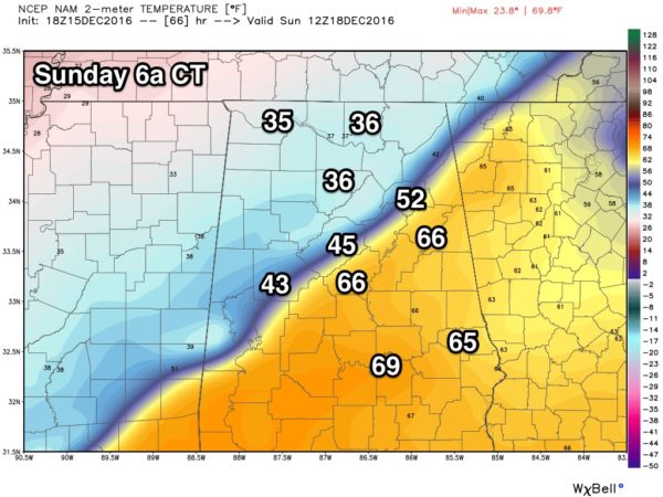
SUNDAY ARCTIC PLUNGE: The Arctic front should be close to I-59 around 6:00 Sunday morning…
If you are south of the front, and wake up with a balmy temperature in the upper 60s, just understand that won’t last long at all; temperatures will fall quickly into the 30s as the front keeps moving southward during the day. Rain will end from northwest to southeast during a Sunday that promises to be raw and very cold.
SLEET/FREEZING RAIN? Still some chance the rain changes to a “wintry mix” of sleet and freezing rain over far North Alabama Sunday before the precipitation ends, but if that does happen little to no impact is expected for now since it won’t last long, and the infrastructure will be warm from the low 70s Saturday. Of course, we will keep an eye on things and let you know if anything changes.
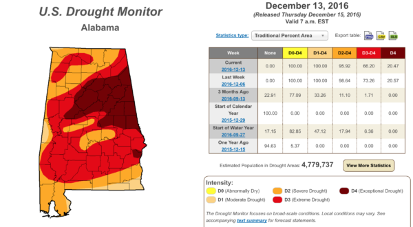
RAIN AMOUNTS: This will be a good rain for the state, with amounts of 1-2″ likely. The new U.S. drought monitor released this morning still shows much of Alabama in a “severe” or “exceptional” drought…
NEXT WEEK AND BEYOND: For now the weather looks dry Monday through Wednesday with cool days and cold nights; rain returns toward the end of the week. And, the Christmas weekend looks mostly cloudy with occasional showers… temperatures should be close to average levels for late December in Alabama with highs between 55 and 60. See the Weather Xtreme video for maps, graphics, and more details.
WEATHER BRAINS: Don’t forget you can listen to our weekly 90 minute netcast anytime on the web, or on iTunes. This is the show all about weather featuring many familiar voices, including our meteorologists here at ABC 33/40.
CONNECT: You can find me on all of the major social networks…
Facebook
Twitter
Google Plus
Instagram
Look for the next Weather Xtreme video here by 7:00 a.m. tomorrow…
Category: Alabama's Weather


