Coldest Air Since February Arrives Today
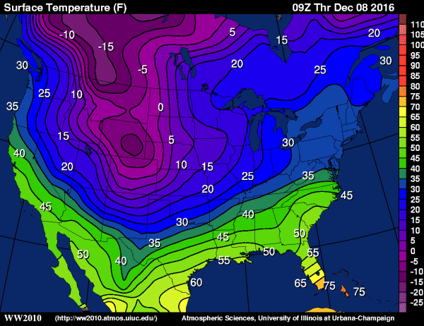
POLAR EXPRESS ALMOST HERE: An Arctic front will blow through Alabama this morning; temperatures won’t change much at all from where we are this morning; mostly lower 40s. And, as the pressure gradient tightens, a north wind of 15-25 mph will develop making it feel colder. The front will come through in mostly dry fashion.
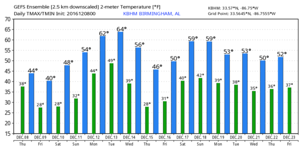
Early tomorrow morning temperatures will drop into the 20-25 degree range, with potential for wind chill indices in the teens. Then, during the day tomorrow, the sun will be back in full force, but the weather stays very cold with a high in the low 40s. Communities north of Birmingham, up in the Tennessee Valley, will hold in the 30s all day.
Saturday morning will also be very cold with low 20s likely for the “official” observation points, but the colder valleys and protected areas will reach the mid to upper teens.
Last time it was this cold was back on February 10 when the low in Birmingham was 23.
THE ALABAMA WEEKEND: Saturday will be sunny with a high in the upper 40s, still about 10 degrees below average for mid December in Alabama. Sunday for now looks dry with a partly sunny sky; the high will be in the mid to upper 50s as a warming trend begins. Clouds increase Sunday night with potential for rain to move into North Alabama.
NEXT WEEK: Let me say up front that forecast confidence is low next week with a tremendous amount of model madness. But, the general idea is that there will be some chance of rain during the first half of the week, followed by another Arctic blast toward Thursday and Friday.
The last few runs of the GFS (the American global model) have been running wild, showing a chance of flurries across North Alabama Wednesday afternoon with temperatures falling through the 30s in the wake of an Arctic front, but the reliable European model (the ECMWF) is totally dry and no Arctic front. We will lean toward the Euro solution here, but I do think cold air returns to the state by Thursday and Friday.
It is important to note there is no firm evidence here of any snow or ice problems for Alabama for the next 7 to 10 days. It is very easy to find dozens of “weather pages and forecast centers” across social media that will give you a snow forecast one to two weeks in advance ANYTIME in every winter season… that is how they get their likes, shares, and clicks. We giggle at the concern over “fake news” these days… we have been dealing with “fake weather” sites for a long time. Welcome to our world.
See the Weather Xtreme video for maps, graphics, and more details.
WEATHER BRAINS: Don’t forget you can listen to our weekly 90 minute netcast anytime on the web, or on iTunes. This is the show all about weather featuring many familiar voices, including our meteorologists here at ABC 33/40.
CONNECT: You can find me on all of the major social networks…
Facebook
Twitter
Google Plus
Instagram
I have a weather program this monrning at Ohatchee Elementary School in Calhoun County… be looking for the next Weather Xtreme video here by 4:00 this afternoon. Enjoy the day!
Category: Alabama's Weather


