More Wet Weather By Saturday Night
BLUE SKY: As advertised, this is a cool, dry day across the great state of Alabama with ample sunshine and temperatures generally in the mid to upper 50s this afternoon. The average high for December 1 (for Birmingham) is 60.
Tonight will be clear and cold; most communities will see a low near the freezing mark early tomorrow, with 20s for the colder spots. And, tomorrow will stay mostly sunny with a high in the low 60s.
RAIN RETURNS OVER THE WEEKEND: Clouds return to Alabama Saturday ahead of the next weather system to the west in this active pattern, and some rain could creep into West Alabama by afternoon. Then, expect periods of rain Saturday night and Sunday. A warm front will be to the south, so it will be a chilly rain with many North Alabama communities holding in the 40s Sunday.
NEXT WEEK: A deepening surface low will move from near Lake Charles to Memphis Monday and Monday night, and the warm front lifts northward, putting much of Alabama in the warm sector. Showers are likely during the day Monday, and then we will have the chance of strong thunderstorms late in the day, Monday night, and into early Tuesday morning. Pretty hard to be specific this far in advance, but for now it looks like severe storms could be an issue again for the state Monday night. We will keep a close eye on severe weather parameters as the event gets closer.
Rain and storms will end Tuesday morning as we get into a dry slot. On the positive side, rain amounts from Saturday night to Tuesday morning will be in the 2 to 4 inch range again for most of the state, very beneficial.
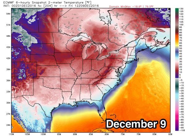
COLDEST AIR SO FAR: An Arctic front will move through Wednesday with a chance of some light rain, and then we will see a shot of very cold air dropping southward from the Yukon. I would expect by Thursday and Friday we will have a hard time getting out of the 30s, and lows could reach the upper teens by Friday or Saturday morning (December 9-10).
HURRICANE SEASON IS OVER: The 2016 Atlantic basin hurricane season ended yesterday. Tthis was the first above-normal season since 2012. The Atlantic saw 15 named storms during 2016, including 7 hurricanes (Alex, Earl, Gaston, Hermine, Matthew, Nicole, and Otto), 3 of which were major hurricanes (Gaston, Matthew and Nicole). NOAA’s updated hurricane season outlook in August called for 12 to 17 named storms, including 5 to 8 hurricanes, with 2 to 4 of those predicted to become major hurricanes.
Five named storms made landfall in the United States during 2016, the most since 2008 when six storms struck. Tropical Storm Bonnie and Hurricane Matthew struck South Carolina. Tropical Storms Colin and Julia, as well as Hurricane Hermine, made landfall in Florida. Hermine was the first hurricane to make landfall in Florida since Wilma in 2005.
Several Atlantic storms made landfall outside of the United States during 2016: Tropical Storm Danielle in Mexico, Hurricane Earl in Belize, Hurricane Matthew in Haiti, Cuba, and the Bahamas, and Hurricane Otto in Nicaragua.
WEATHER BRAINS: Don’t forget you can listen to our weekly 90 minute netcast anytime on the web, or on iTunes. This is the show all about weather featuring many familiar voices, including our meteorologists here at ABC 33/40.
CONNECT: You can find me on all of the major social networks…
Facebook
Twitter
Google Plus
Instagram
I had a great time today visiting with kindergarten students at Striplin Elementary in Gadsden, and with 4th graders at Kitty Stone Elementary in Jacksonville… be looking for them on the Pepsi KIDCAM today at 4:00 and 5:00 on ABC 33/40 News! The next Weather Xtreme video will be posted here by 7:00 a.m. tomorrow…
Category: Alabama's Weather


