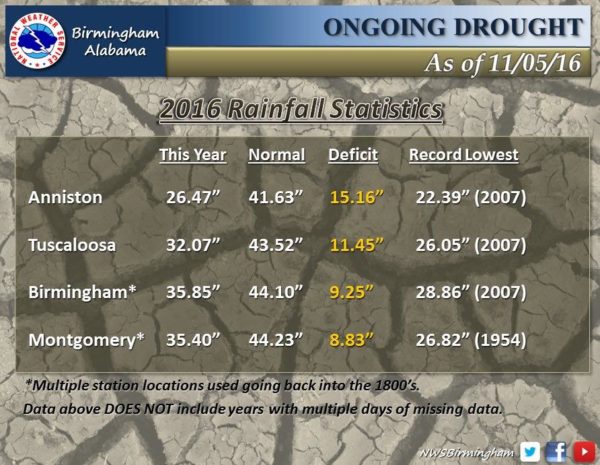
Drought Conditions Continue To Intensity
LOOKING FOR RAIN: The last measurable rain at Birmingham was on September 18 with 0.32?. The last time we had over one inch in a 24 hour period came on July 30, when the total was 1.33?. No rain has been measured so far in November.
So, we have gone, counting today, 50 consecutive days without measurable rain. The record is 52 days set in 1924. If there is no rain, we tie the record Wednesday, and break it Thursday. A very high probability this happens.
TODAY: It will be the warmest day of the week; we project a high in the upper 70s this afternoon with a mix of sun and clouds. Clouds will increase tonight ahead of a weak upper trough.
SPRINKLES TOMORROW? That trough could squeeze out a few raindrops across the state tomorrow, with the best chance coming over the western and southern counties. Odds of measurable rain for places like Birmingham, Tuscaloosa, Anniston, and Gadsden, however, remain very low. The sky will be cloudy at times tomorrow with a high in the low 70s.
WEDNESDAY THROUGH FRIDAY: Sunny pleasant days, clear chilly nights. We expect lows in the 37-41 degree range early Thursday and Friday morning, with highs between 66 and 70. No hope for any rain.
THE ALABAMA WEEKEND: No change; delightful fall weather continues. Highs 66-70, early morning lows 38-42. Blue sky, sunshine, no rain.
FOOTBALL WEATHER: For the high school playoff games Friday, a clear sky with temperatures falling from 60 at kickoff into the upper 40s by the final whistle.
Alabama hosts Mississippi State Saturday (11:00a CT kickoff); the sky will be sunny with temperatures rising from near 65 at kickoff, to 70 by the fourth quarter.
Auburn travels to Athens, GA to take on the Georgia Bulldogs (2:30p CT kickoff)… a perfect day for football. About 68 degrees at kickoff, dropping back into the low 60s by the final whistle.
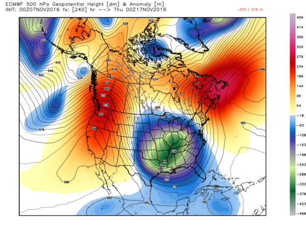
NEXT WEEK: Dry weather continues early in the week, but beyond that the long awaited “pattern flip” comes, and specific forecast details will be hard to define this far in advance. Global models show a deep upper trough forming over the eastern half of the U.S. in 7 to 10 days…
This will open the door, finally, for the return of rain to Alabama and a more active weather pattern. Guidance from the European model (ECMWF) still suggests potential for over five inches of rain between mid-November and mid-December. See the Weather Xtreme video for maps, graphics, and more details.
AT THE BEACH: Expect cloudy periods today through Wednesday with a few passing rain showers, then sunny days and clear nights Thursday through the weekend. Highs will be mostly in the 70s… See a very detailed Gulf Coast forecast here.
TROPICS: The Atlantic basin remains quiet, and tropical storm formation is not expected this week. The hurricane season will end November 30.
WEATHER BRAINS: Don’t forget you can listen to our weekly 90 minute netcast anytime on the web, or on iTunes. This is the show all about weather featuring many familiar voices, including our meteorologists here at ABC 33/40. We will produce this week’s show tonight at 8:30 CT… you can watch it live here.
CONNECT: You can find me on all of the major social networks…
Facebook
Twitter
Google Plus
Instagram
I have a weather program today at Walnut Park Elementary in Gadsden… look for the next Weather Xtreme video here by 4:00 this afternoon. Enjoy the day!
Category: Alabama's Weather


