Mostly Sunny Skies & Warm at the Midday Hour
NICE & WARM DAY WITH A LITTLE BREEZE:
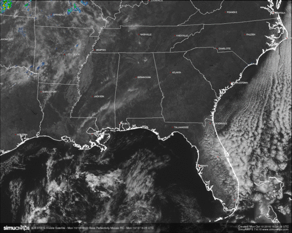
Mostly sunny with a few high clouds will be the outlook for the remainder of the day, with afternoon highs ranging from near 80 to the low 80s. We will have winds out of the east at 5-10 MPH, and with humidity levels dropping into the 20% range during the late afternoon hours, it only raises the dangers for fires. PLEASE do not do any outdoor burning, and stop throwing cigarettes out the car window. Some of the fires have been very close to homes. The Alabama Forestry Commission has issued a Fire Danger Warning for north Alabama that is effective until further notice. The commission urges everyone to delay outdoor burning. This statement is based on antecedent dry conditions and shortage of man power and resources.
NO AIR QUALITY ALERT TODAY:
Ozone and Particulate Matter 2.5 levels will be too low to raise the “Code Yellow” Air Quality Alert for the Birmingham metropolitan area today. No actions needed.
TEMPERATURES ACROSS CENTRAL ALABAMA AT 11:30 AM CDT:
Birmingham 73
Tuscaloosa 73
Gadsden 72
Anniston 72
Cullman 72
Alexander City 74
Auburn 72
Selma 72
Montgomery 74
NORMS AND RECS FOR TODAY IN BIRMINGHAM:
The normal high for October 10th is 77, while the normal low is 53. The record high for today was set back in 1938 at 90. The record low was set back in 2000 at 36.
TOMORROW’S FORECAST:
The morning will start off rather cool again, with temperatures mostly in the 40s, with a few of the colder pockets reaching the 30s. The afternoon will be a carbon copy of today’s weather… Sunshine will be out in full force with just a few high clouds and no rain. Afternoon highs will be in the upper 70s to the low 80s.
HEADED TO THE BEACH:
Sunny days, clear nights on the coast from Gulf Shores to Panama City Beach through the week, with highs mostly in the 80s and lows mostly in the 60s. See a very detailed Gulf Coast forecast here.
TROPICS:
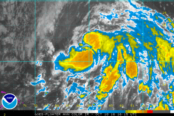
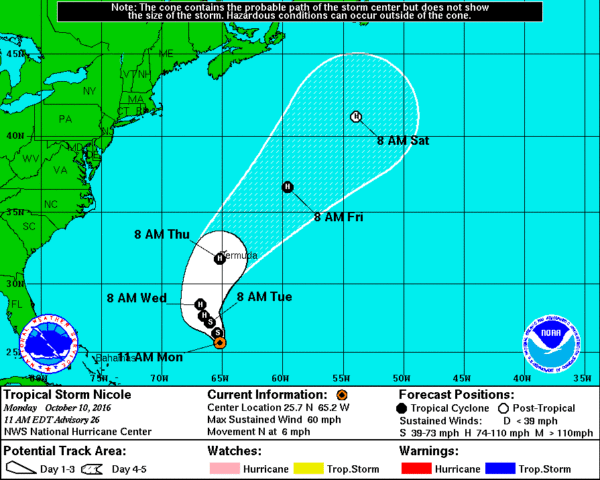
Matthew is now completely off of the board, so now the focus turns to Tropical Storm Nicole. She has now started moving to the north at 6 MPH, and maximum sustained winds are at 60 MPH. Nicole is less organized than yesterday, but is forecasted to strengthen as shear will diminish. Within the next 36 hours, Nicole is forecasted to strengthen into a hurricane as it continues its northward track, and will be close to Bermuda on Thursday morning before being swept off quickly to the northeast out into the open Atlantic by a trough and becoming post-tropical by Saturday morning.
ON THIS DAY IN 1989:
Thunderstorms produced torrential rains along the northeast coast of Florida. Augustine was deluged with 16.08 inches of rain. The heavy rain caused extensive flooding of homes and businesses, and left some roads under three feet of water. Ten cities from South Carolina to New England reported record low temperatures for the date, including Concord NH with a reading of 23 degrees. Temperatures dipped into the 30s in the Carolinas.
THE BLOG IS ON TWITTER:
Be sure to follow the Alabama Wx Weather Blog on Twitter. Just click here to start following our feed.
WEATHERBRAINS:
This is the weekly netcast that’s all about weather featuring many familiar voices, including our meteorologists at ABC 33/40. You can listen anytime on the web, or on iTunes. You can find it here.
ADVERTISE WITH US:
Deliver your message to a highly engaged audience by advertising on the AlabamaWX.com website. The site enjoyed 10.2 MILLION pageviews in the past 12 months. Don’t miss out! We can customize a creative, flexible and affordable package that will suit your organization’s needs. Contact Bill Murray at (205) 687-0782.
Category: Alabama's Weather


