Warmer Next Week; Not Much Hope For Rain
COOLEST MORNING SO FAR: Here are some temperatures across the great state of Alabama just before sunrise…
Black Creek (just northeast of Gadsden) 42
Fort Payne 45
Haleyville 46
Valley Head 46
Russellville 46
Gadsden 47
Concord 48
Tuscaloosa 50
Anniston 50
Bessemer 51
Jemison 51
Birmingham Airport 52
Today will be another delightful early autumn day, with a sunny sky along with a high in the mid 70s.
THE WEEKEND: Sunny days, fair nights, just a slow warming trend. The high tomorrow will be around 80, with low 80s Sunday. Mornings will stay cool with lows mostly in the 50s; 40s are a good possibility for the cooler pockets across North/Central Alabama.
FOOTBALL WEATHER: Looking fantastic for tonight’s high school games; a clear sky with temperatures falling through the 60s during the games (remember, they were falling through the 80s this past Friday night). Some stadiums will see 50s by the fourth quarter, and a light jacket will be in order.
Alabama will host Kentucky tomorrow evening at Bryant-Denny Stadium (6:00p CT kickoff)… the sky will be clear with temperatures falling from 73 at kickoff, into the mid 60s by the fourth quarter.
Auburn hosts Louisiana-Monroe tomorrow at Jordan Hare Stadium (2:30p CT kickoff)… expect a sunny sky with a kickoff temperature of 76 degrees…falling into the upper 60s by the final whistle.
NEXT WEEK: Mostly sunny warm days, fair nights. Highs in the 80s, lows in the 57-63 degree range. A very dry pattern with Hurricane Matthew passing well to the east.
BARBER VINTAGE MOTORCYCLE FESTIVAL: This event runs from Friday October 7 through Sunday October 9 at the Barber Motorsports Park. No real skill in a specific forecast this far out, but October is our driest month of the year, and for now we see nothing to suggest any significant chance of rain event on these three days. Get ticket information right here.
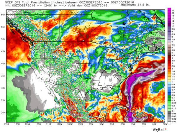
DROUGHT CONDITIONS TO WORSEN: The GFS model is suggesting basically no significant rain for Alabama over the next 10 days…
Be extremely careful if you are doing any outdoor burning; the wildfire danger will remain high for the foreseeable future. And, pay attention to messages from your local water works authorities… water conservation is certainly in order.
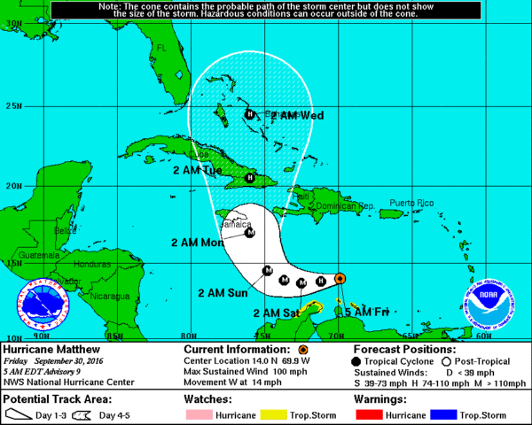
MATTHEW: Now a category two hurricane with sustained winds of 100 mph, a hard right turn is still expected over the Caribbean over the weekend. Matthew will be close to Bermuda Monday as a major hurricane, and over eastern Cuba Monday night and Tuesday.
Matthew will continue northward into the Bahamas next week; it remains to be seen if there will be a direct impact on the U.S. East Coast. Interests all the way from Miami to Cape Cod will need to keep a close eye on this.
WEATHER BRAINS: Don’t forget you can listen to our weekly 90 minute netcast anytime on the web, or on iTunes. This is the show all about weather featuring many familiar voices, including our meteorologists here at ABC 33/40.
CONNECT: You can find me on all of the major social networks…
Facebook
Twitter
Google Plus
Instagram
I have a weather program this morning at Westminster in Shelby County… be looking for the next Weather Xtreme video here by 4:00 this afternoon. Enjoy the day!
Category: Alabama's Weather


