Dancing With the Stats: September’s 90s Drawing to a Close
Saturday was another extremely hot day across Central Alabama with all locations in the upper 90s and a couple of 100F readings. It was 100F at the Mercedes Plant in Vance and at Weedon Field in Eufaula. These readings are some 10-15 degrees above normal for late September.
For the second time this month, the Birmingham Shuttlesworth International Airport hit 98F, which was short of the record for September 24th (99F) set in 1931). Records were set for the second straight day at Anniston, Montgomery and Tuscaloosa with 97F, 98F and 99F respectively.
SUMMER WON’T QUIT: In an average year, we see 6.2 days of 90 degree heat in September in Birmingham. This year, there have been 21 and today will most certainly add another.
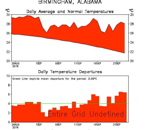
ABOVE NORMAL: The graphic shows the amounts average temperatures have been above “normal”, a statistical term used to smooth the jagged edges of “average” temperatures. You can see, we have certainly been above that normal curve, even on the “cooler’ days of September. In fact, we are running 6 degrees above average so far this month.
EYE OPENING STAT: In a typical June – September period, Birmingham will record 52.3 days of 90 degree heat. We will end 2016 with 91 days of 90+ degree heat. We only hit 100F this summer, so it was a season of extremes, but it was relentless.
ONE MORE DAY, ONE MORE DAY: Let me hear you: one more day… Everyone will be back into the middle and upper 90s today and many spots will hit 90F tomorrow. Will that be the last time this year? Probably not. We have registered a 90F reading as late at October 17th in Birmingham. Highs starting Tuesday will average around 80F into the weekend. Lows will be quite comfortable, with 50s each morning this week starting Wednesday.
ANY RAIN? Not much chance. The cold front that will deliver the cooler temperatures will bring scattered showers and storms tomorrow. But rainfall amounts will average one tenth of an inch.
EYE ON THE TROPICS: What will probably become Matthew is a tropical wave some 1350 miles east of the Lesser Antilles this afternoon. More on that and what might be its impact on the U.S. around 130 p.m.
Category: Met 101/Weather History


