Dry With Hot Afternoons Through Sunday
HELLO FALL: This morning at 9:21 CT the sun will be directly over the equator, and autumn “officially” begins for the northern hemisphere. We have approximately 12 hours of daylight and 12 hours of darkness this time of the year.
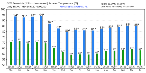
Of course, there is no magic switch when it comes to weather, and the summer-like pattern won’t change through the weekend thanks to an upper ridge overhead and dry air. We will continue to forecast mostly sunny days with hot afternoons, and fair pleasant nights through Sunday… any afternoon showers will be confined to far South Alabama, and even there they should be few and far between. Afternoon highs will remain in the low to mid 90s, about 10 degrees above average for late September.
FOOTBALL WEATHER: For the high school games tomorrow night, the sky will be mostly fair with temperatures falling through the 80s.
Alabama hosts Kent State at Bryant-Denny Stadium Saturday morning (11:00a CT kickoff)… the sky will be partly to mostly sunny with temperatures rising from near 88 at kickoff, to 93 degrees by the final whistle.
Auburn will host LSU at Jordan-Hare Stadium Saturday evening (5:00p CT kickoff)… the sky will be mostly clear with temperatures falling through the 80s.
CHANGES NEXT WEEK: The upper ridge is weakened by an approaching trough, and a cold front will creep closer to Alabama early in the week. This will mean an increase in clouds, a chance of showers, and lower daytime temperatures. Unfortunately, the latest GFS/ECMWF (global model) runs suggest the front won’t be able to push through Alabama, but with it stalling just west and north of here, it looks like there will be some change of badly needed showers each day through the week. And, because of the clouds and showers highs will drop into the 80 to 84 degree range, which is pretty close to average for late September in Alabama (the average high here doesn’t fall into the 70s until early October).
Bottom line is that the days with consistent highs in the 90s will be over after this weekend (until next summer).
AT THE BEACH: Mostly sunny days, fair nights, and a few widely scattered storms on the coast from Panama City Beach over to Gulf Shores through the weekend. Highs in the upper 80s on the immediate coast, low 90s inland. See a very detailed Gulf Coast forecast here.
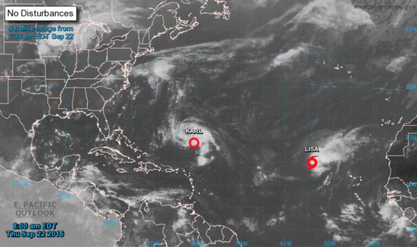
TROPICS: Tropical Depression Karl and Tropical Storm Lisa will recurve over the open Atlantic and are no threat to land; the rest of the Atlantic basin is quiet.
ON THIS DATE IN 1989: Hurricane Hugo roared ashore just north of Charleston, as a massive Category 4 storm with winds near 140 mph and a storm tide around 20 feet. The hurricane leveled beachfront properties and toppled trees, leaving much of the coastal areas in absolute ruin.
Hugo remained strong as it moved into western North Carolina, producing hurricane-force wind gusts all the way to Charlotte. Thirteen people in South Carolina and one person in North Carolina died as a result of the storm (as well as six in Virginia and one in New York). Hurricane Hugo caused $7 billion in damage in the U.S. mainland, making it the costliest hurricane at the time. When adjusted for inflation, it currently ranks as the ninth most costly hurricane in U.S. history, causing almost $13 billion in damage.
WEATHER BRAINS: Don’t forget you can listen to our weekly 90 minute netcast anytime on the web, or on iTunes. This is the show all about weather featuring many familiar voices, including our meteorologists here at ABC 33/40.
CONNECT: You can find me on all of the major social networks…
Facebook
Twitter
Google Plus
Instagram
I have weather programs today at Tarrant Elementary and Erwin Intermediate School… look for the next Weather Xtreme video here by 4:00 this afternoon. Enjoy the day!
Category: Alabama's Weather


