Midday Nowcast: May I Have Another Please?
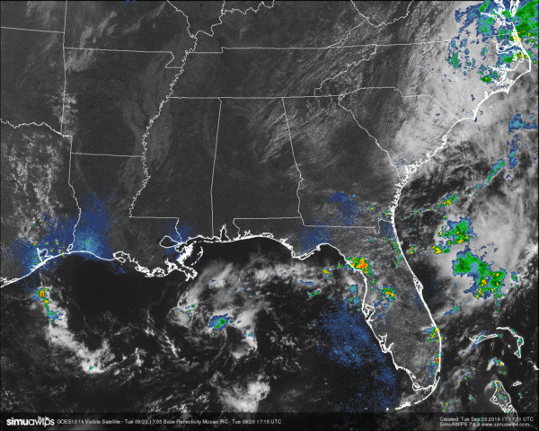
The same weather on a different day… At the noon hour across Central Alabama, radar is clear of any precipitation, and the visible satellite image is mainly clear of any clouds except for a few cumulus clouds floating around the northeastern portions of the area. Looking at the model runs for the area for the rest of the afternoon and evening hours, it will stay mostly clear and dry, with afternoon highs ranging from the upper 80s in the northern parts, to the low 90s in the southern parts of the area. With the lower dewpoint levels today, it will make those temperature a little more comfortable.
TEMPERATURES ACROSS CENTRAL ALABAMA AT NOON:
Birmingham: 88
Tuscaloosa: no report
Gadsden: 86
Anniston: 88
Cullman: 83
Alabaster: 90
Alexander City: 90
Auburn: 88
Montgomery: 88
Selma: 88
ONLY TWO DAYS AWAY FROM FALL’S ARRIVAL:
The Autumnal Equinox takes place on Thursday morning at 9:21 AM CDT, but unfortunately Fall’s arrival isn’t going to help out in the rain department for this week. This dry weather pattern will continue for Central Alabama through the rest of the week and weekend, as skies will be mostly sunny with afternoon highs ranging in the upper 80s to the low 90s. No rain is expected for tomorrow, and any showers that show up during the afternoon hours from Thursday through Sunday will be few and far between. Overnight lows will range in the 60s to 70 degrees.
NEXT WEEK:
Even though a weak front will be approaching according to the latest run of the GFS model, there is not going to be enough upper support and available moisture for an increase in shower chances. We’ll keep an eye on it as we get closer.
TODAY’S CLIMATOLOGY FOR BIRMINGHAM:
The normal high for September 20th is 84, while the normal low is 62. The record high for today was set back in 1925 at 100. The record low was set back in 1918 at 46.
CODE YELLOW AIR QUALITY ALERT:
Particulate matter 2.5 level will be high enough to raise the “Code Yellow” Air Quality Alert for the Birmingham metropolitan area today. Unusually sensitive people should consider limiting prolonged outdoor exertion.
HEADED TO THE BEACH:
About 8 to 10 hours of sunshine daily on the coast from Gulf Shores to Panama City Beach through the weekend with only widely scattered storms. Highs in the upper 80s on the immediate coast, with low 90s inland. See a very detailed Gulf Coast forecast here.
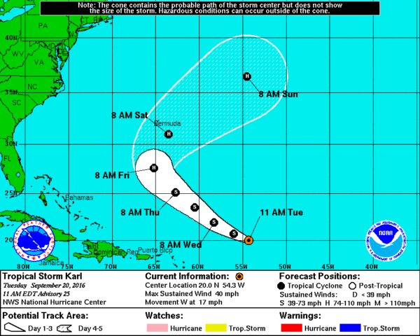
Tropical Storm Karl is in the Central Atlantic, and could become a hurricane this weekend as it turns northward. It might be close to Bermuda Saturday, but it will turn eastward back out to sea, and is no threat to the U.S.
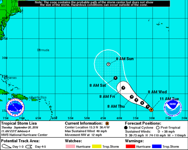
Tropical Depression 13 in the eastern Atlantic became Tropical Storm Lisa earlier this morning, but it will be gaining latitude and doesn’t look like it will bother any land mass, just the fish. The rest of the Atlantic basin is quiet.
ON THIS DAY IN 2005:
Hurricane Rita tracked through the Florida Straits and just south of the Florida Keys. Winds were sustained at tropical storm force at Key West, where peak winds gusted to 76 mph.
THE BLOG IS ON TWITTER:
Be sure to follow the Alabama Wx Weather Blog on Twitter. Just click here to start following our feed.
WEATHERBRAINS:
This is the weekly netcast that’s all about weather featuring many familiar voices, including our meteorologists at ABC 33/40. You can listen anytime on the web, or on iTunes. You can find it here.
ADVERTISE WITH US:
Deliver your message to a highly engaged audience by advertising on the AlabamaWX.com website. The site enjoyed 10.2 MILLION pageviews in the past 12 months. Don’t miss out! We can customize a creative, flexible and affordable package that will suit your organization’s needs. Contact Bill Murray at (205) 687-0782.
Category: Alabama's Weather


