Generally Dry Through The Weekend
A TOUCH OF FALL FOR NORTH ALABAMA: Cullman and Fort Payne have dropped to 61 degrees early this morning; our Skywatcher at Black Creek, just northeast of Gadsden, reports a refreshing 58 degrees. But with a strong September sun, we warm quickly and most places will be close to 90 degrees by mid-afternoon. But, the dew points will be lower, making the warmth a bit more comfortable.
CALM PATTERN CONTINUES: It is safe to say that most Alabamians could use some rain, and would like cooler daytime temperatures. Unfortunately, we really can’t offer much hope for either scenario through the weekend.
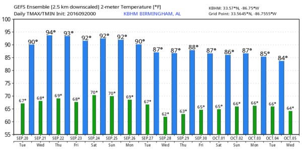
Dry air, and an upper ridge will combine for a very calm, dry pattern through the weekend as we will forecast mostly sunny days, fair nights, and highs in the 88-92 degree range. Birmingham’s average high for September 20 is 84.
RAIN UPDATE: The rain total for September is only 0.68″ (based on data from the Birmingham Airport), and since January 1 the total is 35.85″, a deficiency of 3.68″. For the year the deficiency for Tuscaloosa is 6.04″, and Anniston is down 10.32″ for the year. The dry conditions don’t bode well for the fall foliage season, but remember the colors in Alabama usually don’t peak until the first week of November.
We note the last time Birmingham had over one inch of rain in a single day was back on July 30.
FALL ARRIVES THURSDAY: This is the last Tuesday of the summer of 2016; the autumnal equinox is Thursday morning at 9:21 a.m. CT… when the sun is directly over the equator.
FOOTBALL WEATHER: For the high school games Friday night, the sky will be mostly fair with temperatures falling through the 80s.
Alabama hosts Kent State at Bryant-Denny Stadium Saturday morning (11:00a CT kickoff)… the sky will be partly to mostly sunny with temperatures rising from near 86 at kickoff, to 91 degrees by the final whistle.
Auburn will host LSU at Jordan-Hare Stadium Saturday evening (5:00p CT kickoff)… the sky will be mostly clear with temperatures dropping from near 88 degrees at kickoff to near 80 by the end of the game.
NEXT WEEK: Unfortunately global models don’t offer much hope for a widespread rain event next week as the upper ridge holds. It will break down, but sometimes those things can be very stubborn. See the Weather Xtreme video for maps, graphics, and more details.
AT THE BEACH: Mostly sunny days, fair nights, and only isolated storms through the weekend on the coast from Gulf Shores over to Panama City Beach. Highs in the upper 80s on the immediate coast, with low 90s inland. Sea water temperature early this morning at the Dauphin Island Sea Lab is 85 degrees. See a very detailed Gulf Coast forecast here.
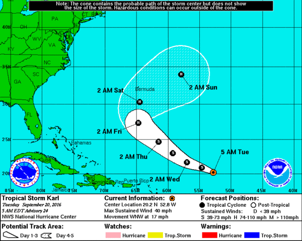
TROPICS: Tropical Storm Karl, in the Central Atlantic, could become a hurricane this weekend, but it will make a sharp u-turn and is no threat to the U.S. It will be close to Bermuda Saturday…
And, Tropical Depression 13 in the eastern Atlantic is expected to become Tropical Storm Lisa later today, but it will gain latitude is not expected to be a threat to any land mass.
WEATHER BRAINS: Don’t forget you can listen to our weekly 90 minute netcast anytime on the web, or on iTunes. This is the show all about weather featuring many familiar voices, including our meteorologists here at ABC 33/40. Scroll down for the show notes on the new episode we recorded last night.
CONNECT: You can find me on all of the major social networks…
Facebook
Twitter
Google Plus
Instagram
I have a weather program this morning at Graham Elementary School in Talladega… look for the next Weather Xtreme video here by 4:00 this afternoon. Enjoy the day!
Category: Alabama's Weather


