Continued Warm with Isolated Showers
Central Alabama waking up to a few clouds this morning, but the radar is clear. A line of storms with some intense lightning moved into the northern sections of Alabama last night ahead of the cold front which was draped across Central Alabama this morning. Tennessee Valley locations saw a little rainfall with a third of an inch or less, but Central Alabama spots remained dry as the storms dissipated. There is a small chance for showers today in Central Alabama while there are slightly better chances for showers across South Alabama. Highs will drop back a little into the upper 80s with the presence of some extra clouds.
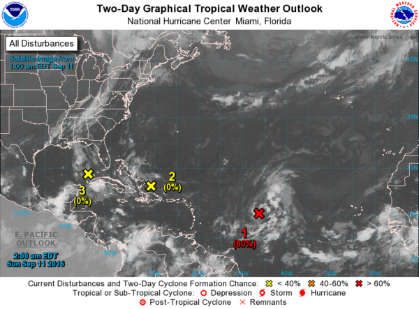
We’re still watching three areas of unsettled weather in the tropics. Feature one is an area of low pressure located about 1000 miles east of the Lesser Antilles and was moving slowly northwestward. Satellite imagery indicates that the circulation has become better defined, but the associated thunderstorms had not become any better organized in the past few hours. Conditions are still favorable for a tropical depression to form during the next day or two while this disturbance moves toward the northwest over the central Atlantic. Feature two is a weak area of low pressure located over the extreme southeastern Gulf of Mexico which remained devoid of thunderstorm activity. Upper-level winds are not favorable for development, and the low is forecast to weaken while it moves westward to west-southwestward at 5 to 10 mph across the central Gulf of Mexico during the next day or two. Feature three is an area of cloudiness and thunderstorms located north of Hispaniola that remained disorganized. There are no signs of a surface circulation, and conditions are not expected to be conducive for significant development of this system while it moves generally west-northwestward at around 15 mph.
Headed for the beach? Mostly sunny days and fair nights are expected with only isolated storms heading into the week ahead. Highs will be in the upper 80s along the immediate coast, with lower 90s inland. The sea water temperature at the Dauphin Island Sea Lab was a very warm 85 degrees. See the complete Gulf Coast 7 Day Planner here.
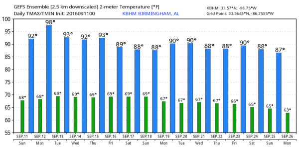
The trough moving through the 500 millibar flow the morning will move quickly to New England later today. So support for the front will wane and the front is expected to wash out today and Monday. Unfortunately, even with a weak front present, the really drier air remained well north of Alabama, so we are not expecting to see any real air mass change. Clouds today will help hold our highs down a bit, but the should recover in the week ahead moving back into the lower 90s.
It is going to remain warm as an upper level ridge builds across the Southeast US into the end of the week. The GFS was weaker with the strength of the ridge in the latest run than we saw yesterday so we probably won’t see temperatures higher than the lower 90s. Moisture remains in place, so it’s going to be hard not to mention the possibility of an isolated shower or storm most days in the week ahead. These should be just diurnal showers driven by the heat of the day since there is really no significant weather feature to produce any real lift.
Showers may become more numerous toward the end of the week as the surface high shifts east and brings our surface flow around to the south. The increased moisture along with an approaching cold front on Sunday could bring up our chances for rain, and we really need some rain. The drought index continued to climb for the northern two-thirds of Alabama.
Looking out into voodoo country, the pattern has it’s ups and downs but no real sign of a significant cold front yet.
The NWA 2016 Conference gets underway today in Norfolk, VA. WeatherFest yesterday was a huge success with over 2,500 people coming through the doors. I had a great time handling the duties for the speaker session with some great speakers like Dr. Marshall Shepherd, Bill Read, and Tony Rice. I expect James Spann to have the next edition of the Weather Xtreme Video first thing on Monday morning. Have a great day and Godspeed.
-Brian-
Category: Alabama's Weather


