Invest 99L And Labor Day Weekend
THE HYPE MACHINE: I still say the open tropical wave known as “Invest 99L” is the most publicized disorganized wave in history. The two primary reasons…
*It has been 3,961 days (almost 11 years) since a major hurricane (category three or higher) has made landfall in the U.S… last one was Hurricane Wilma that hit Florida on October 24, 2005. This is now the longest streak (by far) since hurricane records began in 1851. And, no, “Sandy” wasn’t a “major hurricane” by definition when it moved into the Northeast U.S. in 2012; it was a a category one hurricane morphing into a post-tropical storm.
*Social media now allows anyone and everyone to share weather information and computer models to thousands, if not millions. Twitter didn’t exist the last time a hurricane hit Florida. And, there are many weather enthusiasts and zealots that “want some action”, and do their best to “wishcast” a hurricane by finding that one deterministic 300 hour model run that shows the big one coming up on places like Gulf Shores or Panama City Beach.
Many of these weather amateurs are middle school or high school students, that run sites like “Joe Bob’s Weather Center”, with a corresponding Facebook page. They have learned that the most outrageous hurricane forecasts are the ones that get the attention. When they post long range model output that shows a big storm, they also ask, and almost beg, for you to “like and share”. That is the first warning sign you have stumbled upon a clickbait site with no regard for the truth or ethics.
We want young people to be able to have web sites and Facebook pages, but even a 15 year old has to understand they have great power to deceive the public, and need to keep the information they share within the bounds of meteorologically sound advice. There are many things we don’t know, and many things we can’t do. There is no 15 year old running “Joe Bob’s Weather Center” that knows the intensity and track of a tropical cyclone two weeks in advance.
From those of us in the professional enterprise, I am asking you not to click, like, or especially share bogus weather information concerning things like hurricanes and winter storms, despite the temptation. Look for professional meteorologists, especially those with American Meteorological Society certification like the CBM (certified broadcast meteorologist), or CCM (certified consulting meteorologist). You earn these through academic credentials, a review of your professional work by peers, and a rigorous exam. Sure, those with a CBM or CCM can and will be wrong, but I assure you the information is more solid that “Joe Bob’s Weather Center”.
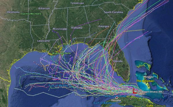
WHAT ABOUT 99L? This morning the wave near the northern coast of Cuba remains disorganized, but is hanging in there. Model output can’t be trusted much since there is no way to initialize the wave, so you see wild output like this (06Z tropical model set)…
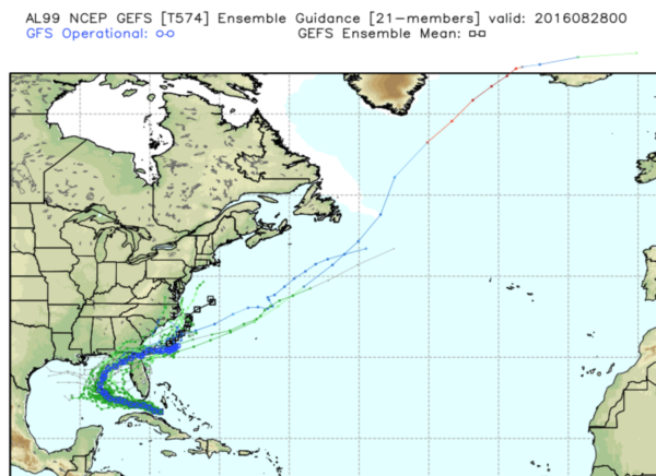
Concerning global models and the ensemble approach (one model using slightly different initial conditions that are all plausible given the past and current set of observations), the GFS has been fairly consistent, suggesting slow development in the eastern Gulf, with a turn to the right over North Florida late this week.
The reliable European model is trending toward this solution, and seems to be a credible idea. If by chance this is correct, most of the rain and inclement weather associated with the wave (it gets the name Hermine if it becomes a Tropical Storm) will remain south and east of Alabama, and east of places like Gulf Shores and Pensacola.
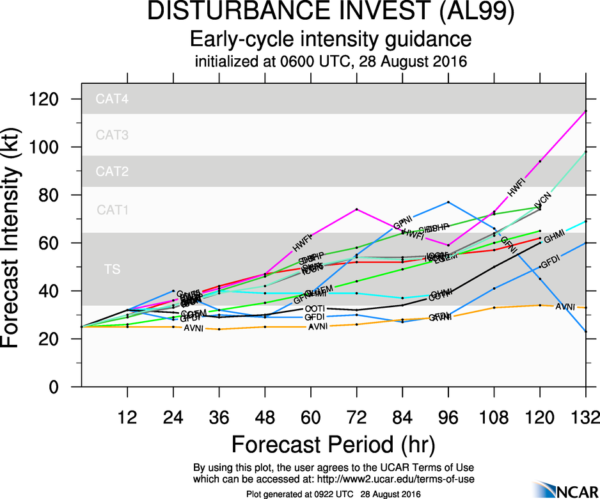
And, intensity guidance suggests a hurricane is not especially likely…
But the bottom line is this… at this time nobody knows the final destination and intensity curve of “99L”, or if it will impact the Central Gulf Coast over the Labor Day weekend. Once we finally get an organized system, we will be able to give you a decent holiday weekend forecast for the various coastal locations. Stay tuned.
Category: Tropical


