Less Showers Today and Sunday
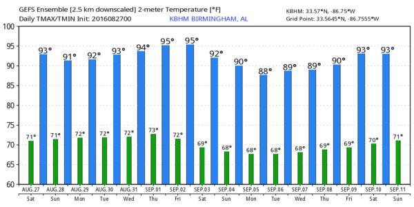
The morning satellite shot shows a few clouds in the Central Alabama sky, so most locations should see a good supply of sun this morning and into the afternoon. Some patchy fog reported mainly in the Tennessee Valley which should burn off pretty quickly. A surface high centered over western Virginia will establish an easterly flow across the Southeast US, so some slightly drier air will advect into Central Alabama. For that reason, we probably won’t see any showers today with our afternoon highs climbing well into the lower 90s.
Gorgeous weather weather along the Gulf Coast with no impacts from the tropics through the weekend. More sun than clouds with only a few passing isolated showers or thunderstorms a possibility. Highs along the beach will be in the upper 80s with overnight lows in the upper 70s. See a very detailed Gulf Coast forecast here.
SPC has little in the way of severe weather risks for the next three days. There area marginal risk areas centered on Chicago and on eastern South Dakota for Day 1; Day 2 there is a small marginal risk area in New York and Pennsylvania and another in Central Minnesota.
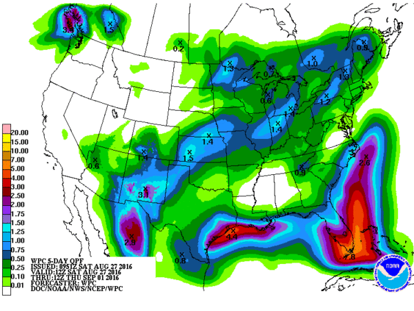
The tropics have come alive with four areas to watch. Gaston is gathering strength and will likely reach hurricane strength early Sunday while it remains in the Central Atlantic. There is one area of disturbed weather just southwest of Bermuda moving westward with only small chances for becoming a tropical storm. We have Invest 99L which has reached the southern Bahamas and continues to be very disorganized. This system once had an 80 percent chance of becoming a tropical storm, but now the short term stands at only 20 percent and the longer term at 40 percent. It is still forecast to move into the Gulf of Mexico into next week. There is yet another area just off the Louisiana coast that stands little chance of becoming a tropical storm.
The dry air today is likely to remain an active player for Sunday keeping our chances for any showers extremely small. The upper ridge remains centered just to our north across Kentucky. While moisture values go up a little especially across the northern third of Alabama, there is still an area of lowered precipitable water values across the Montgomery area. Look for showers to remain isolated with the better chances for seeing one from Birmingham northward. Highs again in the lower 90s.
The upper ridge breaks down a little over the Southeast US and becomes reentered to our west as we see a trough develop along the East Coast. This pattern certainly favors bringing the pesky Invest 99L into the Central Gulf. Recurvature to the north and northeast is a fairly real possibility depending on just how strong the influence of the trough will be on it. The movement of Invest 99L will play a big role in the forecasts for the Southeast US next week, so the forecast could possibly undergo some serious revisions if/when Invest 99L gets its act together. Even if it retains a disorganized pattern, it will mean some rain for some.
Looking out into voodoo country, the GFS is especially bullish on bring the upper ridge back into the Central Plains states so that keeps us in the hot weather as we start September with the westerlies sticking close to the US-Canadian border.
I expect to have the next Weather Xtreme Video posted here first thing on Sunday morning. Stay cool and Godspeed.
-Brian-
Category: Alabama's Weather


