Drier Air Over Far North Alabama
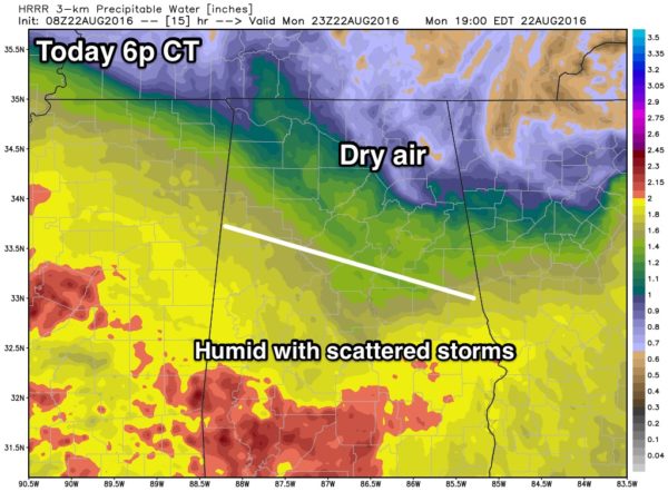
ON THE MAPS: A rare August surface front is over North Alabama this morning; the dew point has dropped to a pleasant 63 degrees at Muscle Shoals, and north of the front most places are seeing temperatures in the 60s. South of the front, the weather is still humid with 70s.
Unfortunately, the front has just about run out of gas, and will hang up a little north of I-20 today. So, those of you in places like Huntsville, Cullman, Gadsden, Florence, Fort Payne, and Scottsboro will enjoy a mostly sunny and less humid day with a high in the 80s.
However, south of the stalled front, scattered showers and storms will fire up this afternoon, generally along and south of I-20. Higher coverage of storms will be over the southern half of the state, and we project a high in the 85-89 degree range for most communities.
REST OF THE WEEK: The front will wash out, and moist air slides northward. And, as an upper ridge builds, we project some very routine August weather tomorrow through Friday. Partly sunny, hot, humid days with the risk of scattered showers and storms during the afternoon and evening hours. Due to the ridge, the coverage of showers and storms each day won’t be as high as recent days, and heat levels will creep up with highs generally in the low 90s.
THE WEEKEND: No real change. Hot and humid, partly sunny days, and an afternoon shower or thunderstorm in spots. Highs 91-94; chance of any one spot getting wet Saturday and Sunday afternoon will be about one in four.
And, the overall pattern won’t change much next week. See the Weather Xtreme video for maps, graphics, and more details.
AT THE BEACH: Nice weather this week from Panama City Beach to Gulf Shores; about 8 to 10 hours of sunshine daily with just a few widely scattered showers or thunderstorms. Highs on the immediate coast 87-90, with low to mid 90s inland. Sea water temperature early this morning at the Dauphin Island Sea Lab is 88 degrees. See a very detailed Gulf Coast forecast here.
TROPICS: As you might expect in late August, things are getting active…
FIONA: This is now a tropical depression fighting very dry air, and should dissipate in coming days far from land over the middle of the Atlantic.
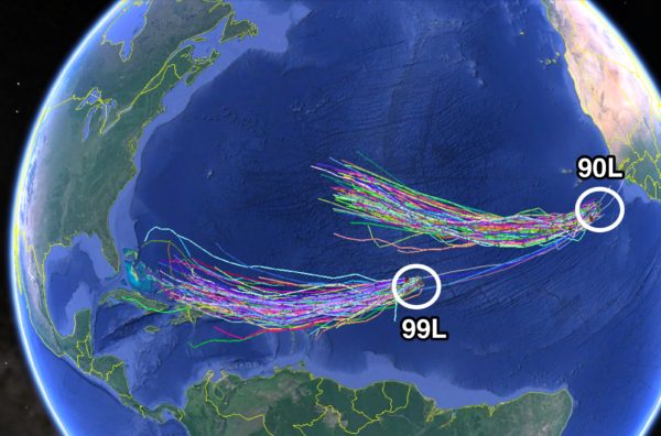
90L: A well organized disturbance in the eastern Atlantic will become a tropical depression soon, and probably will be a tropical storm within 24 hours. But, this will recurve over the Atlantic and won’t be a threat to the U.S.
99L: This is a more latitude system, and could gradually develop this week. If it can get it’s act together, it will begin to gain latitude and miss the Caribbean, and should be east of the Bahamas in five days. Remains to be seen if it will turn toward the southern Atlantic coast of the U.S., or recurve into the open Atlantic. There is a high chance this won’t reach the Gulf of Mexico.
Again, we stress there is no sign of tropical trouble for the Gulf of Mexico for the rest of August. Lots of very bad information floating around social media.
WEATHER BRAINS: Don’t forget you can listen to our weekly 90 minute netcast anytime on the web, or on iTunes. This is the show all about weather featuring many familiar voices, including our meteorologists here at ABC 33/40. We will produce this week’s show tonight at 8:30 CT… you can watch it live here.
CONNECT: You can find me on all of the major social networks…
Facebook
Twitter
Google Plus
Instagram
Look for the next Weather Xtreme video here by 4:00 this afternoon… enjoy the day!
Category: Alabama's Weather


