Midday Nowcast: Soupy Air and More Showers
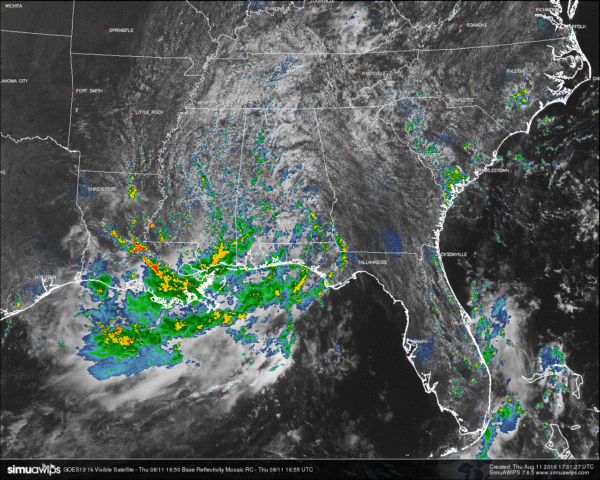
The pesky low that won’t leave is still causing mostly cloudy skies across Central Alabama, along with a soupy airmass and spotty showers on radar. Most of the shower activity is located in the western parts of the state, especially east of I-65 and south of US-278. All of these are moving off to the northwest, as they rotate around the low that is currently located over eastern Louisiana just north of Lake Pontchartrain.
TEMPERATURES AT THIS HOUR: With the clouds and rainfall, temperatures are being held back in some spots. Here is a list of temperature observations from across the area:
Birmingham 79
Tuscaloosa 83
Gadsden 82
Anniston 84
Cullman 78
Hamilton 80
Clanton 80
Alexander City 80
Montgomery 83
WHAT TO EXPECT FOR TODAY: Skies will be mostly cloudy with occasional showers throughout the remainder of the afternoon and early evening hours, with afternoon highs in the upper 80s for most in Central Alabama. Heavier rain amounts will stay south and west of the area. Most of the shower activity should dissipate by 10PM tonight.
CODE GREEN AIR QUALITY: The Air Quality Index for the Birmingham Metropolitan Area is in the “Code Green” for ozone and particulate matter 2.5. No actions needed.
TODAY’S CLIMATOLOGY FOR BIRMINGHAM: The normal high for August 11th is 91, while the normal low is 69. The record high for today was set back in 2007 at 102. The record low was set back in 1969 at 58.
FRIDAY’S WEATHER: Not much change from today to tomorrow. Skies will be mostly cloudy with occasional showers mainly during the afternoon and evening hours, even though rain could fall at anytime throughout the day. Showers could be thinning out a little bit, so possibly not as much in coverage as in recent days. Afternoon highs will be in the upper 80s to near 90.
HEADED TO THE BEACH: Mostly cloudy weather continues through tomorrow on the Gulf Coast from Gulf Shores to Panama City Beach with occasional rain and thunderstorms; a flash flood watch is up from Dauphin Island to Orange Beach to Destin, and dangerous rip tides are likely. Weather conditions will gradually improve this weekend and early next week with increasing amounts of sun and fewer showers. See a very detailed Gulf Coast forecast here.
THE TROPICS: All remains quiet across the Atlantic basin, and tropical storm formation is not expected through the week.
ON THIS DAY IN 1987: An early evening thunderstorm in Wyoming produced hail up to two inches in diameter from Alva to Hulett. Snow plows had to be used to clear Highway 24 south of Hulett, where hail formed drifts two feet deep. (The National Weather Summary)
THE BLOG IS ON TWITTER: Be sure to follow the Alabama Wx Weather Blog on Twitter. Just click here to start following our feed.
WEATHERBRAINS: This is the show all about weather featuring many familiar voices, including our meteorologists at ABC 33/40. You can listen anytime on the web, or on iTunes. You can find it here.
ADVERTISE WITH US: Deliver your message to a highly engaged audience by advertising on the AlabamaWX.com website. The site enjoyed 10.2 MILLION pageviews in the past 12 months. Don’t miss out! We can customize a creative, flexible and affordable package that will suit your organization’s needs. Contact Bill Murray at (205) 687-0782.
Category: Alabama's Weather


