Midday Nowcast: Hot With Showers Possible, and Earl Is Close to Hurricane Strength
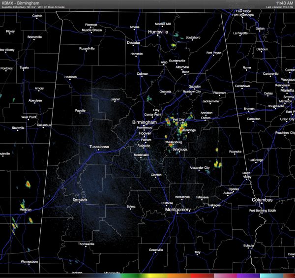
Mostly clear skies and warm temperatures grace Central Alabama at this hour, but we already have showers develop this morning and are continuing to move to the south-southeast at about 10 MPH. Currently a few heavy showers are located near Moody, Pell City, Lincoln, and Childersburg, and lightning has just started to show on these. Elsewhere across Central Alabama, radar is clear.
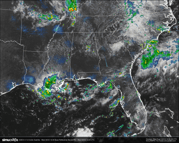
Looking back to our north and northwest, we see that a cluster of storms are making their way toward the southeast out of Missouri and into northeastern Arkansas. There is a possibility that those could make it into the northern parts of the state this afternoon if it holds together. There is also an outflow boundary just ahead of that near Memphis that is making its way southeast and could be a catalyst for more shower and storm development this afternoon in the state. We’ll see what happens and keep you updated.
TEMPERATURES AT THIS HOUR: With the skies being mostly clear out there for the most part, the temperatures are climbing. Here is a list of temperature observations from across the area:
Birmingham 85
Tuscaloosa 88
Gadsden 85
Anniston 82
Cullman 83
Hamilton 88
Clanton 86
Alexander City 85
Montgomery 89
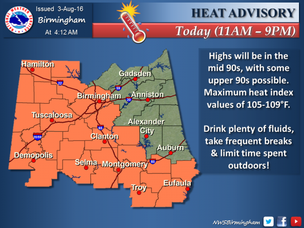
WHAT TO EXPECT FOR TODAY: Skies will remain partly to mostly clear across Central Alabama throughout the remainder of the afternoon and evening hours, with a risk of scattered afternoon showers and thunderstorms. Once again we will watch to see if and development happens with the outflow boundary that will be moving into the northwestern corner of the state this afternoon. Afternoon highs will be mostly in the mid 90s, with a few places reaching the upper 90s. A Heat Advisory is in effect for much of western and southern parts of the area until 9PM tonight, with heat index values expected to reach the mid to upper 100s. Rain should dissipate by 10PM, and overnight lows will be in the 70s.
CODE YELLOW AIR QUALITY: The Air Quality Index for the Birmingham Metropolitan Area will be in the “Code Yellow” for ozone and particulate matter 2.5. Unusually sensitive people should consider limiting prolonged outdoor exertion.
TODAY’S CLIMATOLOGY FOR BIRMINGHAM: The normal high for August 2nd is 91, while the normal low is 70. The record high for today was set back in 1947 at 100. The record low was set back in 1976 at 63.
THURSDAY’S OUTLOOK: Another hot and humid day expected for tomorrow, with a risk of scattered showers and thunderstorms mainly during the afternoon, but a few could form during the late morning hours. Highs will once again be back up mostly in the mid 90s with a few spots reaching the upper 90s. Heat index values will once again be above 100 degrees. The odds for any one spot getting rain tomorrow will be a little better than 1 in 3.
HEADED TO THE BEACH: Scattered showers and storms will be the rule along the Gulf Coast through the weekend. The chance of rain on any given day will be about 40 percent. Highs will be around 90 while lows will be in the upper 70s. Water temperatures are hovering just below 90 degrees which is about as warm as it gets in the Gulf. There may be some rip current issues, so please pay attention to the flags posted along the beaches. See a very detailed Gulf Coast forecast here.
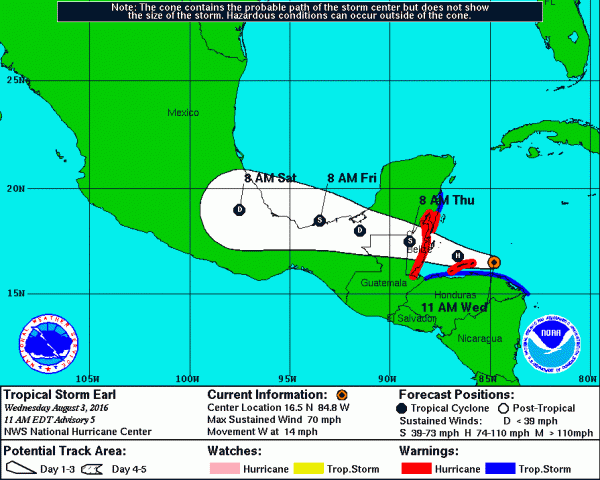
THE TROPICS: Tropical Storm Earl went through an eye replacement overnight with the new center forming a little south of the previous position. Currently, Earl is just below hurricane strength and continues to chug westward at 14 mph and may reach hurricane intensity before going ashore in Belize. The track forecast does bring the storm over the extreme southern edge of the Bay of Campeche late Friday and early Saturday. It could restrengthen into a tropical storm for a short period before entering Mexico.
THE BLOG IS ON TWITTER: Be sure to follow the Alabama Wx Weather Blog on Twitter. Just click here to start following our feed.
WEATHERBRAINS: This week, the panel entertained Charlie Woodrum, who is the Warnings Coordination Meteorologist for the NWA Central Pacific Region. This is the show all about weather featuring many familiar voices, including our meteorologists at ABC 33/40. You can listen anytime on the web, or on iTunes. You can find it here.
ADVERTISE WITH US: Deliver your message to a highly engaged audience by advertising on the AlabamaWX.com website. The site enjoyed 10.2 MILLION pageviews in the past 12 months. Don’t miss out! We can customize a creative, flexible and affordable package that will suit your organization’s needs. Contact Bill Murray at (205) 687-0782.
Category: Uncategorized


