A Nice Sunday but Warmer Weather Ahead
The day starting off on a pleasant note with morning lows dipping into the upper 50s. Thanks to high pressure centered off to our northwest, we will see some slightly drier air settle into the state on northerly wind flow. Look for highs around the 80-degree mark, but it will feel even nicer with that drier air.
For any beach goers, you can expect mostly sunny days and fair nights through the week ahead all the way from Dauphin Island to Panama City. Great weather for the rest of the Hangout Music Festival today. Highs on the immediate coast will be 80 to 82 degrees. The water temperature early this morning at the Dauphin Island Sea Lab was 79 degrees. See the complete Gulf Coast 7 Day Planner here.
Today is the final day of the golf tournament at the Greystone Golf and Country Club. Plenty of sunshine and warm temperatures are what you can expect for the final round of the tournament today. No threat of rain as drier air settles into the area. Be sure to have the sunscreen handy. Click here for Regions Traditions Tickets.
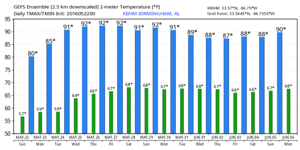
College baseball heats up the Hoover Met for this week with SEC Baseball Tournament starting Tuesday and running through Sunday, May 24th to 29th. The weather looks pretty good for the tournament although it will be getting warmer as high temperatures reach the 87 to 90 degree range for most days; there could be isolated afternoon showers from Wednesday through the end of next week, but nothing widespread is anticipated. If heading out to the Hoover Met, be sure to take the sunscreen! Click Here For Event and Ticket information.
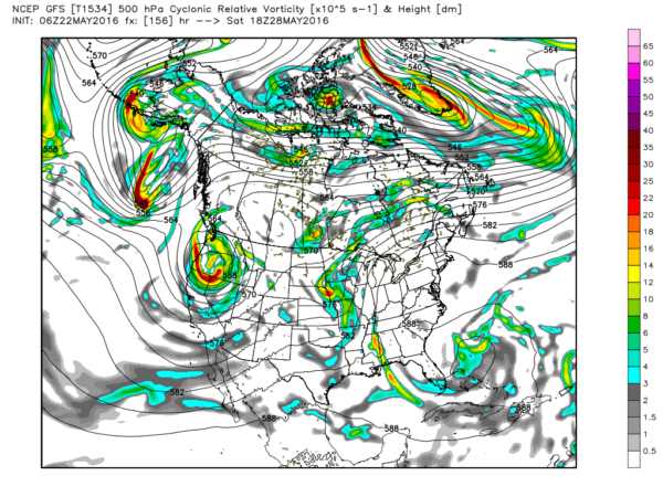
The upper ridge just to our west is separating two troughs, one over the West Coast and one over the East Coast. It is that trough that will be the primary feature in our weather pattern for about the next week. This will allow temperatures to climb well into the 80s with most locations reaching highs in the range of 87 to 91. This will be one of the first prolonged periods of warm weather, so be sure to be careful working in the heat and don’t overdo it. Without any specific feature in our weather pattern besides the ridge, I expect the warm afternoon temperatures will generate widely scattered thunderstorms in the afternoons starting Wednesday and running to the end of the week.
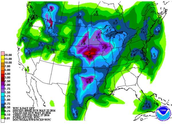
With the ridge firmly in place over the eastern half of the country, the threat for severe weather will remain to our west primarily across the Central Plains states and into the Ohio River Valley states.
The ridge begins to show signs of weakening around Friday and Saturday as the deep trough over the western states sends a strong short wave northeastward. This short wave trough will beat down the ridge into next weekend, so showers are likely to become more numerous as we head into the next weekend. But there is no indication that we’ll see anything more than scattered thunderstorms.
Remember the discussion yesterday about week 2 or voodoo country. Well that very interesting feature along the Gulf Coast is completely out of the long range model projections. In fact, there is a suggestion that June could start with a little less heat. And that is followed by the potential for a strong trough coming across the Mississippi River around the 5th and 6th of June bringing the potential for some widespread rain.
I want to thank the folks at Altoona for the warm reception Meaghan Thomas and I had yesterday at the Altoona Festival. It’s always nice to chat with folks about our favorite topic, the weather.
James Spann should have the next edition of the Weather Xtreme Video first thing on Monday morning. Check back here often for updates on the Alabama weather scene. Enjoy the day and Godspeed.
-Brian-
Category: Alabama's Weather


