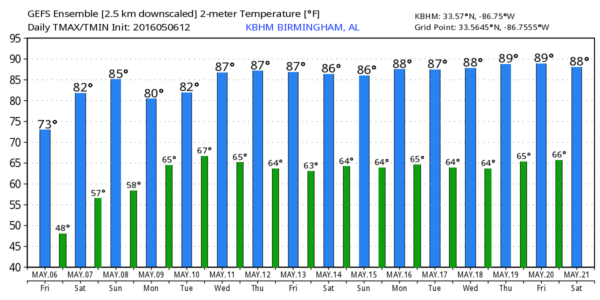
Weekend Warming Trend Ahead
DRY AIR: With a sunny sky, temperatures are generally in the low 70s across North/Central Alabama this afternoon. We do note some smoke has moved into the state from the north; that smoke has origins in the big Fort McMurray wildfire in Canada.
Temperatures will warm into the low 80s tomorrow, and mid 80s Sunday as a warm-up begins; the air stays dry over the weekend and the sky will be sunny both days.
NEXT WEEK: Monday will stay warm and dry, but we will need to mention a risk of showers and thunderstorms Tuesday as moisture returns and an upper trough approaches. Good news is that dynamic support will weaken and severe weather isn’t especially likely. Moist air will remain in place and we will need to mention some risk of showers, and possibly a thunderstorm or two, Wednesday and Thursday, but the rain won’t be continuous. See the Weather Xtreme Video for maps, graphics, and more details.
AT THE BEACH: Sunny days, clear nights through Monday from Gulf Shores over to Panama City Beach, and a decent part of next week should be dry as well. Highs in the upper 70s along the immediate coast; 80s inland. See a very detailed Gulf Coast forecast here.
WEATHER BRAINS: Don’t forget you can listen to our weekly 90 minute netcast anytime on the web, or on iTunes. This is the show all about weather featuring many familiar voices, including our meteorologists here at ABC 33/40.
CONNECT: You can find me on all of the major social networks…
Facebook
Twitter
Google Plus
Instagram
I had a great time today visiting with the students at Holt Elementary School… be looking for them on the Pepsi KIDCAM today at 5:00 on ABC 33/40 News! My next Weather Xtreme video will be posted early Monday morning by 7:00… Brian Peters will have the video updates tomorrow and Sunday. Enjoy the weekend!
Category: Alabama's Weather


