Unsettled Weather Continues Today and Monday
If you are looking for the weather to settle down, you’ll have to wait a couple more days. The main player was a surface low in southern Illinois with a cold front trailing back into Southeast Texas. That along with a moist southwesterly flow aloft will help to keep the weather unsettled across much of the Southeast US for the next couple of days. Showers with some embedded thunderstorms are likely today, but temperatures will remain warm even with the cloudy conditions with highs today and Monday generally close to the 80-degree mark.
If you are heading to the beach, look for a mixture of sun and clouds with the daily threat of scattered showers and storms through Tuesday. Sunshine and dry conditions will prevail for the latter half of the week ahead. High temperatures will be in the upper 70s along the immediate coast but in the mid and upper 80s inland. The sea water temperature at Perdido Pass at Orange Beach was 77 degrees. See the complete Gulf Coast 7 Day Planner here.
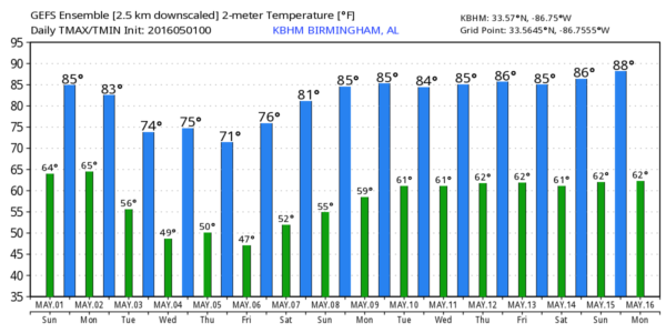
The upper trough over Iowa will continue to move eastward Monday and Tuesday keeping the moist, southwesterly flow in place across the Southeast US. Since the front remains essentially parallel to the upper flow, the frontal boundary will remain in the area until Tuesday and Wednesday when the upper flow changes with the development of a big ridge in the west and a deep trough across the eastern states. This will sweep the frontal boundary out of the area on Tuesday, so we should begin to see conditions dry out during the day Tuesday. With the changes aloft, temperatures will dip back with highs Tuesday and Wednesday in the middle 60.
Because the frontal boundary will remain in place for the next couple of days, rainfall amounts could total 1 to 2 inches in places. Hard to be very specific due to the nature of the showers.
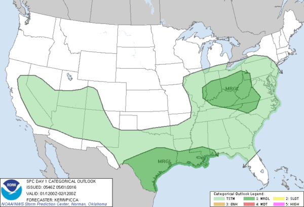
With the absence of any really strong dynamics, the SPC has only marginal risks for severe weather defined for the next three days.
By Wednesday and Thursday the upper trough is established over the eastern US, so look for some beautiful weather with highs in the lower 70s. As the surface high slowly migrates eastward, Friday morning should see our coolest morning with many locations across Central and North Alabama dipping back into the 40s for a pleasantly cool start to the day. Plenty of sunshine will see highs climb into the 70s, a little below where we typically see high temperatures for early May.
Mother’s Day weekend is looking good as the surface high slides off into the Southwest Atlantic while the upper ridge moves over the eastern US.
As we frequently see when we peruse the projections into week 2 or voodoo country, the GFS has changed its mind on the weather pattern. Instead of well defined systems, the GFS is now pushing the main westerly flow and storm track well north of the southern tier of the US, so we stay in a weakly zonal flow as the main traveling upper air features travel along the US-Canadian border. This would mean a summer-like weather pattern for us with warm weather and the presence of scattered showers nearly every day.
I had a great time with the rest of the ABC 3340 gang out at Veterans Park in Hoover for Celebrate Hoover Day. The weather was good and it was nice to chat with all the ABC 3340 fans. James Spann will be back with the next edition of the Weather Xtreme Video first thing on Monday morning. You can find notes about Alabama’s weather by checking back here frequently. Have a great day and Godspeed.
-Brian-
Category: Alabama's Weather


