Warm, Unsettled Weekend Weather
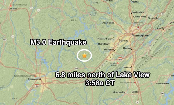
QUIET MORNING: Nothing on the radar as this day begins; temperatures are mostly in the 60s. The most excitement involves the report of a small earthquake on the Tuscaloosa/Jefferson County line at 3:58 a.m…. only a M3.0 meaning most slept right through it.
We will forecast a partly sunny sky today with a high well up in the 80s; it will be one of the warmest days so far this year.
We are watching an MCS (mesoscale convective system) moving into Arkansas; this could very well move into Northwest Alabama late this afternoon, although it will be weakening at the time. While most of the day will be dry, we will introduce the risk of a few scattered showers or storms late this afternoon, with higher coverage over Northwest Alabama due to the MCS.
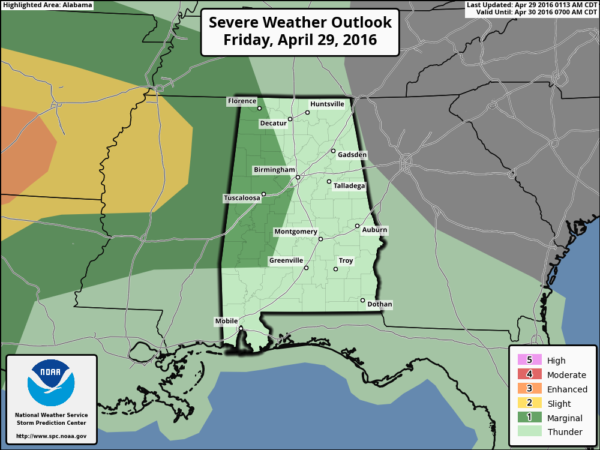
The risk of a shower or storm will continue tonight. SPC has a “marginal risk” of severe weather defined for parts of far West and Northwest Alabama; a few storms could produce gusty winds, but the overall severe weather threat is low.
THE ALABAMA WEEKEND: A big upper trough will be lifting out of the western U.S.; the surface low underneath will slowly weaken as it moves east/northeast. Moist air will cover Alabama, and we will need to mention the risk of a few showers and storms both tomorrow and Sunday. Giving specific start/stop times for the rain is almost impossible in this setup, and model guidance is not very consistent.
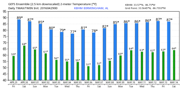
Bottom line is that you will need to be ready for a few passing showers or storms tomorrow and Sunday, but the rain won’t be continuous and the sun will be out at times. A strong storm or two is possible, but the severe weather threat is very low with weakening upper dynamics. The high tomorrow will be in the mid 80s, with low 80s Sunday afternoon.
NEXT WEEK: Model madness is the story for Monday and Tuesday. The American model (the GFS) is dry, but the European model (ECMWF) looks wet both days; based on the Euro’s better track record, we will forecast mostly cloudy weather both days with some risk of rain at times. The latter half of the week will be dry and cooler; a decent chance some spots will drop into the cool 40s by Thursday or Friday morning. See the Weather Xtreme video for maps, graphics, and more details.
RACE WEEKEND AT TALLADEGA: Partly sunny and very warm today with a high between 84 and 87 degrees. We can’t rule out a shower after 3 p.m., but the day will be generally dry.
For tomorrow and Sunday, expect a mix of sun and clouds both days with the risk of a passing shower or storm from time to time. Unfortunately in this pattern, we aren’t able to give specific times when the rain will pass through, but the good news is that we don’t expect a big rain mass to set in for hours. A very good chance they get the Sparks Energy 300 in on Saturday, and the GEICO 500 in on Sunday, but a delay is very possible both days. Keep an eye on radar.
And, please remember the 8 mile lightning rule. Lightning within 8 miles, you get inside. Car, truck, building, etc. I don’t mess around with it, and you shouldn’t either.
AT THE BEACH: About 7 to 9 hours of sunshine today and tomorrow on the coast from Panama City Beach over to Gulf Shores with only a small risk of a shower. Scattered showers and storms are possible Sunday and Monday… highs in the 70s on the immediate coast, with 80s inland. See a very detailed Gulf Coast forecast here.
WEATHER BRAINS: Don’t forget you can listen to our weekly 90 minute netcast anytime on the web, or on iTunes. This is the show all about weather featuring many familiar voices, including our meteorologists here at ABC 33/40.
CONNECT: You can find me on all of the major social networks…
Facebook
Twitter
Google Plus
Instagram
I will be speaking at Spring Valley School in Birmingham this morning, and then at the Books A Million corporate HQ for a weather safety program. And, this evening, I will be at Regions Field for a special tornado safety night at the Birmingham Barons game. Look for the next Weather Xtreme video here by 4:00 this afternoon… enjoy the day!
Category: Alabama's Weather


