Warm, Dry Weather For Alabama
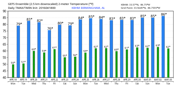
BIG WARM-UP TODAY: We are starting the day in the 47-52 degree range for most places, but with sunshine in full supply, we rise to near 80 degrees this afternoon thanks to an upper ridge in place across the eastern U.S.
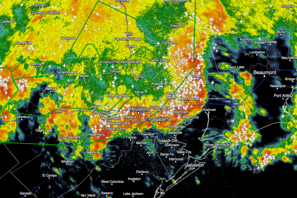
TO THE WEST: We should note that while we enjoy a beautiful day, the omega block upper air pattern is setting up a very dangerous flood situation in Southeast Texas; some places west of Houston have received over 15 inches of rain as I write this early this morning, and a flash flood emergency is in effect for Harris and Montgomery Counties.
TOMORROW/WEDNESDAY: Warm, dry weather continues tomorrow with ample sunshine and a high in the low 80s. Then, on Wednesday, the omega block breaks down, and moisture begins to return. Clouds will begin to increase, and a few spots could see an afternoon shower. The weather stays warm Wednesday with a high around 80 degrees.
RAIN RETURNS: Showers and storms will return to Alabama Thursday and Thursday night as an upper trough approaches, but for now severe weather is not expected. Rain amounts will be around 1/2 inch.
FRIDAY AND THE WEEKEND: The sky becomes partly sunny Friday as the upper trough moves on to the east with a high in the mid 70s, and then we expect a delightful weekend with sunny days and fair nights. The high Saturday will be in the upper 70s, followed by low 80s Sunday afternoon.
HONDA INDY GRAND PRIX OF ALABAMA: Weather is looking fantastic for the event this weekend… partly sunny Friday, sunny Saturday and Sunday. Very comfortable afternoons. Get ticket information here.
AT THE BEACH: Dry through Wednesday from Panama City Beach over to Gulf Shores, then a chance of showers and storms Thursday. Dry weather follows Friday, and the weekend looks very nice with sunny days and fair nights Saturday and Sunday. Highs generally in the 70s… and the sea water temperature early this morning at the Dauphin Island Sea Lab is 67 degrees. See a very detailed Gulf Coast forecast here.
NEXT WEEK: Dry weather continues Monday… looks like the next risk of showers/storms will come late Tuesday into Wednesday. And, for now, it doesn’t look like a severe weather threat. See the Weather Xtreme video for maps, graphics, and more details.
WEATHER BRAINS: Don’t forget you can listen to our weekly 90 minute netcast anytime on the web, or on iTunes. This is the show all about weather featuring many familiar voices, including our meteorologists here at ABC 33/40. We will produce this week’s show tonight at 8:30 CT…. you can watch it live here.
CONNECT: You can find me on all of the major social networks…
Facebook
Twitter
Google Plus
Instagram
I have a weather program this morning at Piedmont Elementary School…. look for the next Weather Xtreme video here by 4:00 this afternoon. Enjoy the day!
Category: Alabama's Weather


