Simply Gorgeous ! !
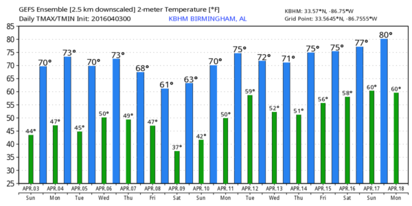
Alabamians waking to a beautifully clear sky this morning. Nearest clouds are well south in the Central Gulf of Mexico. With high pressure centered over the Southeast US, we saw a chilly morning with lows into the 40s. We’ll be seeing another gorgeous day today very similar to yesterday with highs in the 60s, mainly upper 60s.
Headed to the beach? Great weather expected along the beaches of Alabama and Northwest Florida. Lots of sunshine and dry weather are in the forecast today through much of next week. Expect a good supply of sunshine each day with highs mostly in the 70s. See the complete Gulf Coast 7 Day Planner here.
A strong upper trough will be moving through the Great Lakes Region on Monday, but it will not extend very far south so it will just be a glancing blow for us. As the surface low pass New York City, a weak front will drag through the Southeast US on Monday. With little moisture to work with, we should just see some passing clouds before the sky clears again by Tuesday morning. Monday should be warm with highs into the lower 70s, but we’ll be a bit cooler on Tuesday with highs dropping back into the 60s.
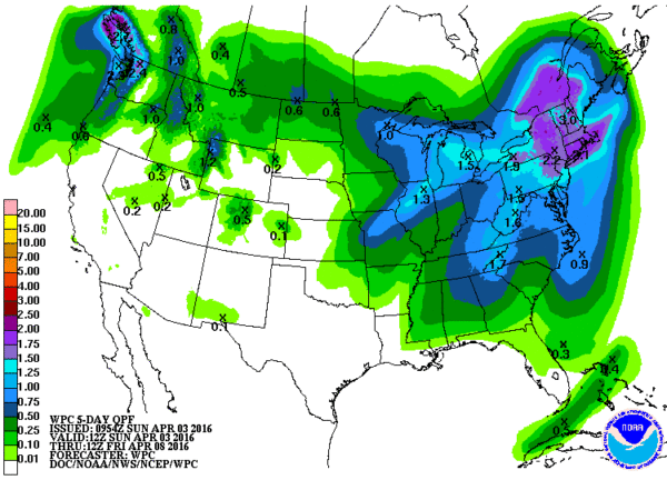
Tuesday and Wednesday should be good weather for us, though Wednesday we’ll begin to see some changes. A trough will move across the Middle Mississippi River Valley Wednesday afternoon and early Thursday with a surface low in the vicinity of Chicago and a cold front stretching southwestward to Southeast Texas. The approach of the front on Wednesday will bring come clouds plus rain chances will increase Wednesday afternoon and into the first half of Thursday. It still looks doubtful for any severe weather with this system due in part to the limitation of any really deep moisture. With this system moving by pretty briskly, rainfall amounts should be limited with amounts around half an inch. Highs Wednesday will be around 70 and nearly the same on Thursday.
But look for Friday and Saturday to be much chillier with the establishment of the long wave trough over the eastern US once again. The trough has the most southward push on Friday, but look for the morning lows on Saturday to be rather chilly. GFS MOS guidance is still printing out a low of 37 for Birmingham, and with the surface high directly over Alabama, we should have excellent conditions for good radiational cooling. Frost will be a good possibility, but with a low of 37 degrees at Birmingham, we could see some of those normally colder, sheltered locations drop even colder with some locations reaching the 32-degree mark. Some sort of frost/freeze advisory may be required.
But you know the routine. Sunday the high moves off to the east taking our surface flow around to the south and southwest, so we warm up nicely by Sunday with lows in the lower 40s and highs back into the 70s.
Voodoo country still looks active with a low latitude trough in the April 11th/12th time frame that may well produce a severe weather setup. The GFS is still forecasting a fairly strong ridge around the 14th and 15th, but it is not nearly as strong as the one predicted yesterday. But the 17th/18th the GFS 500 millibar chart becomes rather noisy.
Don’t forget that we have the basic storm spotter training event set for Tuesday, April 5th, at the Civic Center/Community Center in Helena. The program starts at 6:30 and we usually end around 8:15. Hope to see you there. Next weekend, April 9th, we have Storm Spotter Xtreme at the BJCC from 9 am to about 3 pm. The basic spotter training session will be given in the morning with presentations from the ABC 3340 staff as well as a representative of the NWS. The advanced spotter training session will come in the afternoon. Plus you get admission to the Birmingham International Car Show.
James Spann will have the next Weather Xtreme Video for you first thing on Monday morning. Please enjoy this beautiful day. Godspeed.
-Brian-
Category: Alabama's Weather


