Tornado Watch Expanded in North Alabama to the East
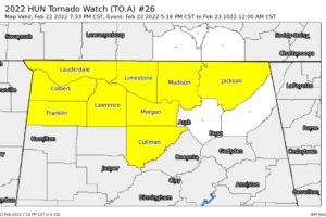
NWS Huntsville adds Jackson County to the TORNADO WATCH that is set to expire at midnight tonight.

NWS Huntsville adds Jackson County to the TORNADO WATCH that is set to expire at midnight tonight.

At 726 PM CST, a severe thunderstorm capable of producing a tornado was located near Rogersville, or 14 miles west of Athens, moving east at 50 mph.

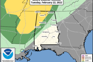
The SPC has updated the Day One Severe Weather Outlook for the rest of today, and they have expanded the Slight Risk for severe storms slightly to the east. The Slight Risk is up for locations along and west of a line from Aliceville (Pickens Co.) to Warrior (Jefferson Co.) to Valley Head (DeKalb Co.).

At 701 PM CST, a severe thunderstorm capable of producing a tornado was located near Leighton, or 9 miles east of Muscle Shoals, moving east at 50 mph.

At 650 PM CST, a severe thunderstorm was located over Sheffield, moving east at 50 mph.

At 639 PM CST, Doppler radar was tracking a strong thunderstorm 8 miles west of Sulligent, moving northeast at 55 mph.

The Storm Prediction Center has issued a TORNADO WATCH effective immediately and is set to expire at midnight tonight. North Alabama counties in the watch include: Colbert, Cullman, Franklin, Lauderdale, Lawrence, Limestone, Madison, and Morgan. Central Alabama counties in the watch include: Fayette, Greene, Lamar, Marion, Pickens, Sumter, Tuscaloosa, Walker, and Winston.

Conditions are calm for the moment across Central Alabama, but rain and storms will move into the area this evening. We continue to see the threat of isolated strong to severe storms across the north and west parts of the area, and a watch may be issued over the next couple of hours.

RADAR CHECK: The radar is pretty quiet at mid-afternoon across Alabama… we have a mix sun and clouds with temperatures mostly in the low to mid 70s. A few spots over West Alabama are not too far from 80 degrees, including Tuscaloosa. An approaching cold front will bring the chance of strong to severe thunderstorms to parts of North and West Alabama tonight; SPC maintains a “slight risk” (level 2/5) of severe thunderstorms for areas north of a line from Fort Payne to Oneonta to Northport to Aliceville. A “marginal risk” (level 1/5) extends down to Jacksonville, Alabaster, and Livingston.

We are seeing more clouds than sun today and a few scattered showers, but we are watching storms to our northwest ahead of cold front that will push into Alabama later today.

This week’s Guest WeatherBrain is Mikayla Smith, a senior at the University of Oklahoma majoring in meteorology and minoring in broadcasting and mathematics. She’s the senior weather producer at OU Nightly and is also the weekend meteorologist for News12-TV in Sherman, TX.

ACTIVE PATTERN CONTINUES: A warm front has moved out of Alabama early this morning; radar shows a few showers over the Tennessee Valley just before daybreak… the rest of the state is cloudy with temperatures not too far from 60 degrees. Look for a high in the mid 70s today with a few scattered showers around during the morning and midday hours. Then, strong to severe thunderstorms are possible ahead of a cold front this evening and tonight over parts of North and West Alabama.
Notifications