Hurricane Helene Makes Landfall in Florida Big Bend
Hurricane Helene has officially made landfall in the Florida Big Bend region as a Category 4 hurricane at approximately 11:10 PM EDT (0310 UTC).

Hurricane Helene has officially made landfall in the Florida Big Bend region as a Category 4 hurricane at approximately 11:10 PM EDT (0310 UTC).

This situation poses an extremely dangerous and life-threatening threat to the area. Locations affected include Lake Park, Valdosta, Quitman, Thomasville, and several others.

Helene is located approximately 75 miles northwest of Cedar Key and about 40 miles southeast of Tallahassee, with maximum sustained winds reaching 140 mph (220 km/h). The storm is currently moving north-northeast at 24 mph (39 km/h) and is expected to make landfall soon.

As of 10:00 PM EDT, the eyewall of the extremely dangerous Category 4 Hurricane Helene is starting to move ashore along Florida’s Big Bend coast.

As of 8:59 PM EDT, extreme winds from the eyewall of Hurricane Helene, moving at 35 mph, are coming ashore 39 miles southeast of Carrabelle. This is an extremely dangerous and life-threatening situation!

Hurricane Helene has strengthened slightly as its eye approaches the Florida Big Bend. As of 9:00 PM EDT, a monitoring station in Cedar Key recorded sustained winds of 55 mph, with gusts up to 73 mph. A NOAA tide gauge in Clearwater Beach showed water levels 5.07 feet above the normal high tide, indicating some flooding in that area.

Location: 80 miles west-southwest of Cedar Key, Florida; 115 miles south of Tallahassee. Winds: 130 mph (Category 4 hurricane). Movement: North-northeast at 23 mph.

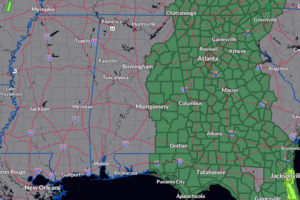
Current radar as of 6:20pm shows that any rainfall falling across Alabama is over on the eastern side of the state.

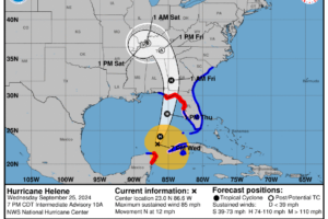
At 1000 PM CDT (0300 UTC), the center of Hurricane Helene was located near latitude 23.1 North, longitude 86.6 West. Helene is moving toward the north at 9 mph (15 km/h).

Hurricane Helene continues to churn her way over the Yucatán Channel and will soon be entering the southern Gulf of Mexico.

With the latest shift a little to the west in the projected path of Helene, the following watches, warnings, and advisories may be extended westward as well.

With Helene racing toward the Florida Big Bend Region, plenty of moisture will be pulled north and very heavy rain and the risk of flooding in place for parts of Alabama.

Helene is located near 19.9°N, 85.5°W, about 100 miles ESE of Cozumel, Mexico, and 145 miles SSW of the western tip of Cuba. The storm is moving WNW at 10 mph with sustained winds of 60 mph. Minimum central pressure is 991 mb.

Storms have weakened across North and West Central Alabama, but activity is expected to pick back up overnight and into tomorrow afternoon, with strong storms possible southeast of I-59.
 Our long time friend, mentor, and charter Weather Factory member, J.B. Elliott, passed away on May 11, 2015. Click HERE to read James' tribute.


