Wednesday Evening Notes
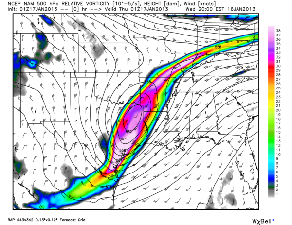
Here is a look at the deep, cold core upper low that will swing through Alabama tomorrow….
After a peek at late model data tonight, don’t see much reason to change our ongoing forecast…
Some points to consider before going to bed….
*As I have stated here in recent days, we have a limited skill set in dealing with snow output from cold core upper lows like this. No two systems act the same, and I can almost guarantee you there will be surprises. Some of you will get more snow than you expect, and others will see nothing more than a flake or two. There is very little skill in identifying the exact placement of the heaviest band of snow.
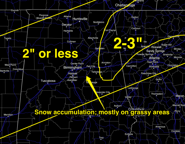
*No doubt the best chance of the higher accumulation will be across the high terrain of East and Northeast Alabama. I bet Dave Baird on the air tonight we will see five inches on the ground at Cheaha State Park. But, keep in mind the elevation there is 2,407 feet. It will be fun to watch our SKYCAM there tomorrow.
*Snow will begin just before sun-up over far West Alabama, and progress east during the day. Snow should begin in Tuscaloosa in the 5:00 to 7:00 a.m. time frame… Birmingham by 8:00 a.m….. and Anniston/Gadsden by 9:00 a.m. Keep in mind these are rough estimates and could change. All of the snow will be over mid to late afternoon as the upper low moves quickly to the northeast.
*I still believe that we won’t have any serious travel issues tomorrow. Even where 2 inches of snow accumulates on grass, roads will be just wet. The ground and infrastructure is warm, and surface temperatures tomorrow should remain above freezing throughout the day. It is very hard for Alabamians to believe this when snow begins to fall heavily, but even with the heavier snow bursts, roads will be wet. But, remember, we have lots of wrecks around here on rainy days, so take it easy even with just wet roads.
*If any moisture lingers tomorrow night, there could be a touch of “black ice” in spots on bridges and overpasses. But, most of the moisture will evaporate by then.
*In the overall scheme of things, this is a “good” snow setup since we don’t expect any real travel issues, and many places across North-Central Alabama will have enough snow for a good snow ball fight, or maybe even enough for a snow man.
*For any school delays, please see the ABC 33/40 site.
I will have a fresh discussion and a new Weather Xtreme video here posted by 6:30 a.m. tomorrow. Stay tuned…
Category: Alabama's Weather


