Warm, Unsettled Weekend
**No Weather Xtreme video this afternoon due to travel… I am in New Orleans to speak to an AMS conference tomorrow**
THIS AFTERNOON: Below is a screen grab of the radar at mid-afternoon…
We will maintain the risk of scattered showers through the evening hours.
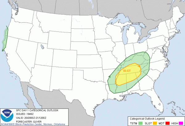
TONIGHT/TOMORROW: Since my early morning discussion, SPC has placed their standard “slight risk” of severe up for parts of North and Central Alabama late tonight and tomorrow. Below is the convective outlook for tonight…
An approaching short wave will increase dynamic lift late tonight, and a few strong storms will likely develop over the state. As usual in January, the main limiting factor is the lack of instability, with surface based CAPE values generally at 500 j/kg or less.
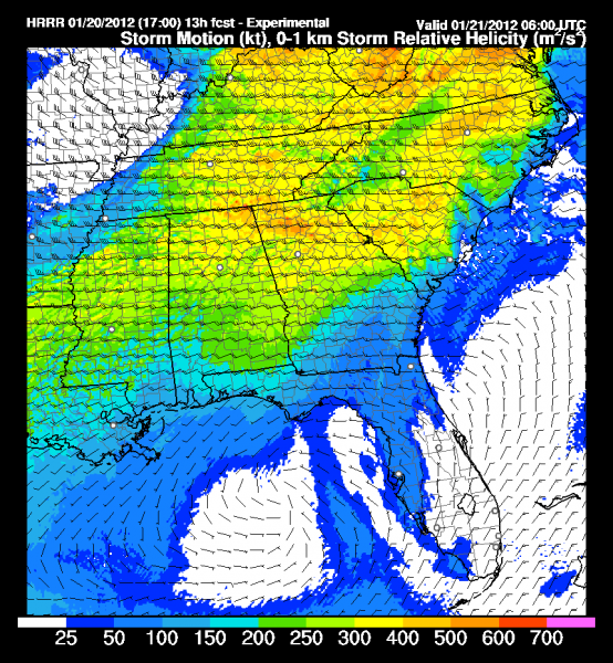
Below is the HRRR look at 0-1 km storm relative helicity at midnight tonight, and that is certainly adequate for organized updrafts…
Looks like the main window for strong to severe storms will be from about midnight tonight through 12:00 noon tomorrow. Understand this is not a major severe weather threat at all, but one or two warnings might be required for storms that try to rotate after midnight. Tornadoes, if we have any at all, more than likely will be short lived and relatively weak.
But, when it comes to thunderstorms expected the unexpected, and be sure and have a NOAA Weather Radio available late tonight and tomorrow, or a good smart phone app, in case warnings are needed. This is the app we recommend; at this moment it is for iPhone only, but an Android version will be available within a few weeks. Be sure and choose ABC 33/40 as your station of choice so you can see our severe weather coverage on your phone or iPad.
SUNDAY: A decent chance we hit the low 70s Sunday, about 20 degrees above average for mid-January, and within about 5 degrees of record levels. A few scattered showers remain possible with low level moisture pooled across the southern U.S.
A deep, negative tilt upper trough north of Alabama will set the stage for more strong storms Sunday night into Monday morning. It will be similar to the event tonight and tomorrow; marginal instability values, but pretty decent shear. We will monitor that for signs of severe weather over the weekend; the stronger storms most likely will be in here between midnight Sunday night and 9:00 a.m. Monday.
NEXT WEEK: Tuesday will be dry with a good supply of sunshine and a high around 60. Another rain/storm event is shaping up for the latter half of the week, but model differences make it difficult to be very specific this far in advance.
WEATHER BRAINS: Don’t forget you can listen to our weekly 90 minute netcast anytime on the web, or on iTunes. This is the show all about weather featuring many familiar voices, including our meteorologists here at ABC 33/40.
CONNECT: You can find me on all of the major social networks…
Brian Peters will cover my TV shift tonight on ABC 33/40, and he will also produce the Weather Xtreme videos tomorrow and Sunday. I will be back in the saddle Monday… enjoy the weekend, and stay tuned to the blog for updates on the Alabama thunderstorm situation late tonight and tomorrow.
Category: Alabama's Weather


