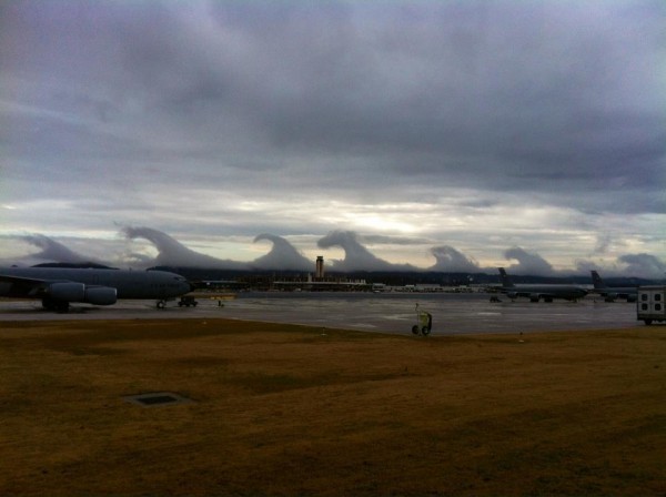
Kelvin-Helmholtz Wave Clouds Over B’ham
These images were sent in by a number of our readers/viewers at midday… the first shot below is from the Alabama Air National Guard facility at the Birmingham-Shuttlesworth International Airport…
This one is from I-65…
Below is the view from one of the taller buildings in downtown Birmingham…
Another one from downtown…
Another image from an office in downtown Birmingham…
This video is from that same office building…
The video below is from the Red Mountain Expressway…
From the Cloud Appreciation Society… The breaking waveforms of Kelvin-Helmholtz clouds are the result of shearing winds up at cloud level. A particular type of turbulence can develop in a layer of cirrus cloud, which happens to form below an inversion between air currents of differing speeds and/or directions. Sea waves break as their bases are slowed down upon reaching shallow water and their crests surge ahead. Cloud waves break in the same way: when their crests are pushed ahead of their troughs by the difference in air currents.
If you want to peg the geek meter, see the wikipedia article here.
Just another reminder the weather around here is rarely “boring”….
Category: Alabama's Weather


Comments (33)
Trackback URL | Comments RSS Feed
Sites That Link to this Post