

Midday Nowcast: Dog Days of Summer
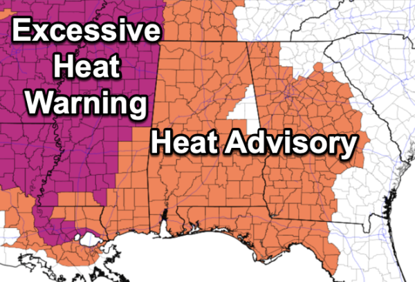
Officially we are in them as they run from July 3rd through August 11th, more about them in a minute. The weather is hot and very humid with highs in the mid to upper 90s for most places this afternoon. Moisture levels are rising as dew points are in the 70s, and that is causing heat index values to climb into the danger range across most of Alabama. A heat advisory continues for most of Alabama today, and likely for the next several days. Rain chances today are low across the northern half of the state, but will begin to rise in the coming days as well.
HEAT ADVISORY: Hot temperatures and high humidity may cause heat illnesses as heat index values up to 109° are expected across much of Alabama. With hotter weather in the forecast, these advisories will likely be extended through the weekend.
BIRMINGHAM ALMANAC: For July 3rd, the average high for Birmingham is 90° and the average low is 71°. The record high is 101° set in 1970, while the record low is 57° set in 1924. We average 0.18” of precipitation on this date, and the record value is 2.76” set in 1940.
DOG DAY HISTORY: The term “Dog Days” traditionally refers to a period of particularly hot and humid weather occurring during the summer months of July and August in the Northern Hemisphere. In ancient Greece and Rome, the Dog Days were believed to be a time of drought, bad luck, and unrest, when dogs and men alike would be driven mad by the extreme heat! Today, the phrase doesn’t have up such bad imagery. Instead, the Dog Days are associated purely with the time of summer’s peak temperatures and humidity.
This period of sweltering weather coincides with the year’s heliacal (meaning “at sunrise”) rising of Sirius, the Dog Star. Sirius is part of the constellation Canis Majoris—the “Greater Dog”—which is where Sirius gets its canine nickname, as well as its official name, Alpha Canis Majoris. Sirius is the brightest star in the sky, not including our own Sun. It was believed that Sirius’s dawn rising in mid-to-late summer contributed to the extreme weather of the season. In other words, the “combined heat” of super-bright Sirius and our Sun was thought to be the cause of summer’s sweltering temperatures.
Of course, the appearance of Sirius does not actually affect seasonal weather here on Earth, but its appearance during the hottest part of summer ensures that the lore surrounding the star lives on today!
USA BRIEF: Excessive heat with potential records will continue to impact much of the West through Independence Day and into next week. Triple digit high temperatures are expected this weekend in parts of the Pacific Northwest. Dangerous heat will persist this week in the Southern Plains, Gulf Coast, Southeast, and Mid-Atlantic. Heat index values will approach or exceed 110 degrees at times.
INDEPENDENCE DAY WEEKEND: It is a long holiday weekend for most folks and scattered showers and storms will become more numerous across Alabama as the air becomes more unstable, and moisture levels rise. The chance of any one spot getting wet tomorrow and Friday are in the 30/40 percent range, rising into the 50/60 percent range Saturday and Sunday. Highs will remain in the mid to upper 90s. Heat index values will be in the danger range, and we are likely to see more Heat Advisories through the weekend.
NEXT WEEK: We will roll with a persistence forecast. Hot, humid, with those daily showers and thunderstorms around mainly during the afternoon and evening hours. Expect highs in the 90s and lows in the 70s.
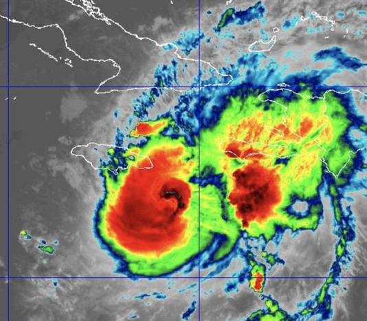
IN THE TROPICS: Hurricane Beryl is heading towards Jamaica and should make landfall as a major hurricane later today. At 1100 AM EDT, the center of Hurricane Beryl was located near latitude 17.1 North, longitude 76.1 West. Beryl is moving toward the west-northwest near 18 mph, and this general motion should continue through today, followed by a turn more toward the west tonight or Thursday. On the forecast track, the center of Beryl will pass near or over Jamaica during the next several hours. After that, the center is expected to pass near or over the Cayman Islands tonight or early Thursday and move over the Yucatan Peninsula of Mexico Thursday night or early Friday.
Reports from NOAA and Air Force Reserve Hurricane Hunter aircraft indicate that maximum sustained winds are near 145 mph with higher gusts. Beryl is a category 4 hurricane on the Saffir-Simpson Hurricane Wind Scale. Some weakening is forecast during the next day or two. However, Beryl is forecast to be at or near major hurricane intensity while it passes near Jamaica later today and the Cayman Islands tonight or early Thursday. Additional weakening is expected thereafter, though Beryl is forecast to remain a hurricane in the northwestern Caribbean.
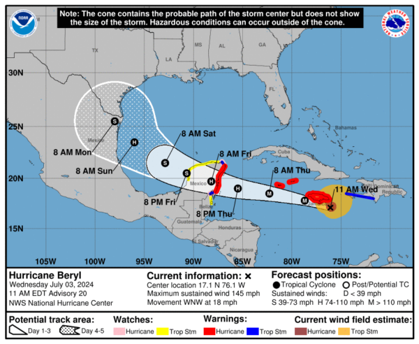
Hurricane-force winds extend outward up to 45 miles from the center and tropical-storm-force winds extend outward up to 185 miles. The latest minimum central pressure estimated from Air Force Reserve Hurricane Hunter aircraft data is 954 mb (28.17 inches).
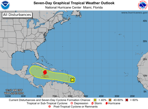
We are still watching Invest 96L which is trailing Beryl, but the chance of development remains low. Shower and thunderstorm activity remains disorganized in association with a tropical wave located a couple of hundred miles east of the Windward Islands.Development, if any, of this system should be slow to occur while it moves quickly westward to west-northwestward at 20 to 25 mph across the Caribbean Sea. Regardless of development, gusty winds and locally heavy rainfall are possible across portions of the Lesser Antilles today. Formation chance through 7 days…low…20 percent.
Next name up is Debby and the rest of the basin is quiet.
BEACH FORECAST CENTER: Highs in the upper 80s and low 90s with storms on a daily basis. Water temperatures are very warm with mid-80s being reported up and down the Northern Gulf Coast. PLEASE pay attention to the Rip Current Flags System at each beach for the update on rip currents as the rip current threat will be increasing heading into the weekend.
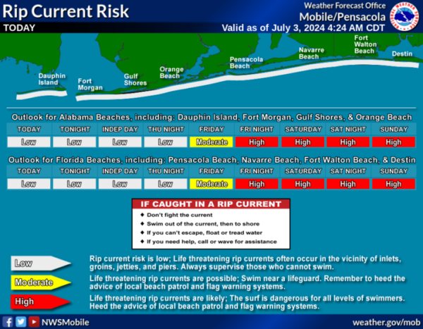
Get the latest weather and rip current forecasts for the beaches from Fort Morgan to Panama City on our Beach Forecast Center page. There, you can select the forecast of the region that you are interested in visiting.
WORLD TEMPERATURE EXTREMES: Over the last 24 hours, the highest observation outside the U.S. was 120.9F at Adrar, Algeria. The lowest observation was -101.2F at Concordia, Antarctica.
CONTIGUOUS TEMPERATURE EXTREMES: Over the last 24 hours, the highest observation was 119F at Death Valley, CA. The lowest observation was 22F at Mackay, ID.
Category: Alabama's Weather, ALL POSTS
About the Author (Author Profile)
Macon, Georgia Television Chief Meteorologist, Birmingham native, and long time Contributor on AlabamaWX. Stormchaser. I did not choose Weather, it chose Me. College Football Fanatic. @Ryan_StinnetSubscribe
If you enjoyed this article, subscribe to receive more just like it.


