

Midday Nowcast: Increasing Heat Levels; Beryl Remains a Category 5
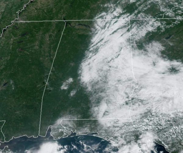
HOT AND HUMID SUMMER DAYS: Highs will be in the mid 90s for most places this afternoon. Any showers or storms will be confined to the southern third of the state, and even there most places will stay dry. Moisture levels rise tomorrow, and we will mention the chance of an afternoon shower or thunderstorm in scattered spots. The high will be in the be in the mid to upper 90s and those heat index values will be approaching the danger range of 105°. For this reason, a Heat Advisory has been issued for portions of Alabama.
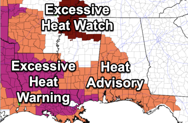
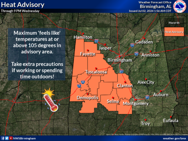
HEAT ADVISORY: Hot temperatures and high humidity may cause heat illnesses as heat index values up to 105 are expected through Wednesday evening across portions of West and Central Alabama. With hotter weather in the forecast later this week, additional advisories will be likely needed through this week.
BIRMINGHAM ALMANAC: For July 2nd, the average high for Birmingham is 90° and the average low is 71°. The record high is 101° set in 1954, while the record low is 57° set in 1924. We average 0.18” of precipitation on this date, and the record value is 2.43” set in 1989.
USA BRIEF: Severe thunderstorms are expected mainly from Kansas into northern Missouri and Iowa this afternoon and evening. Damaging winds, a few tornadoes, and large hail are the expected hazards. Excessive rainfall may bring areas of flooding to parts of the Midwest today. Hot to dangerously hot conditions will impact much of California and from the central Plains to the northern Gulf Coast today.
INDEPENDENCE DAY WEEKEND: It is a long holiday weekend for most folks and scattered showers and storms will become more numerous across Alabama as the air becomes more unstable, and moisture levels rise. The chance of any one spot getting wet these days is 30/40 percent, rising into the 50/60 percent range Saturday and Sunday. Highs will remain in the mid to upper 90s. Heat index values will be in the danger range, and we are likely to see more Heat Advisories through the weekend.
NEXT WEEK: We will roll with a persistence forecast. Hot, humid, with those daily showers and thunderstorms around mainly during the afternoon and evening hours. Expect highs in the 90s and lows in the 70s.
IN THE TROPICS: Hurricane Beryl remains a very powerful category 5 hurricane. Beryl is a historic storm, being the earliest category 5 hurricane on record in the Atlantic Basin, and only the second category 5 during the month of July (Emily 2005).
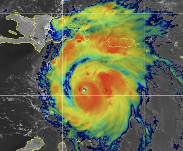
The center of Hurricane Beryl was located near latitude 15.3 North, longitude 68.9 West. Beryl is moving toward the west-northwest near 22 mph, and this general motion should continue through Wednesday, followed by a turn more toward the west on Thursday. On the forecast track, the center of Beryl will move quickly across the central Caribbean Sea today and is forecast to pass near Jamaica on Wednesday and the Cayman Islands on Thursday. The center is forecast to approach the Yucatan Peninsula of Mexico on Thursday night.
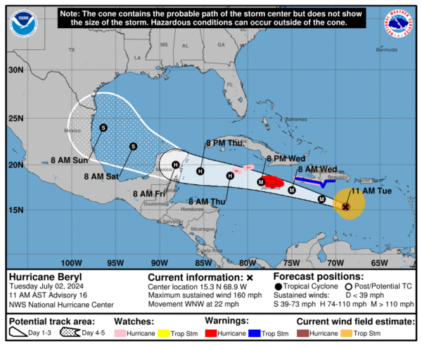
Reports from Air Force Reserve and NOAA Hurricane Hunter aircraft indicate that maximum sustained winds are near 160 mph with higher gusts. Beryl is a category 5 hurricane on the Saffir-Simpson Hurricane Wind Scale. Weakening is forecast later today, but Beryl is still expected to be near major hurricane intensity as it moves into the central Caribbean and passes near Jamaica on Wednesday and the Cayman Islands on Thursday. Additional weakening is expected thereafter, though Beryl is forecast to remain a hurricane in the northwestern Caribbean.
Hurricane-force winds extend outward up to 40 miles from the center and tropical-storm-force winds extend outward up to 175 miles. The latest minimum central pressure estimated from the Hurricane Hunter aircraft data is 938 mb (27.70 inches).\
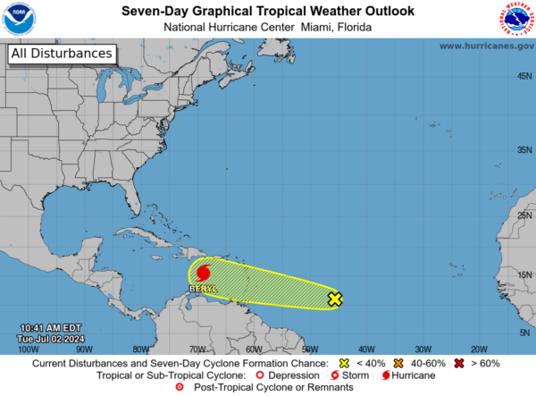
Behind Beryl, we are watching Invest 96L which is a tropical wave located about 1000 miles east-southeast of the Windward Islands is producing limited shower and thunderstorm activity. Environmental conditions are only marginally conducive for development of this system while it moves generally westward at 15 to 20 mph across the western tropical Atlantic and eastern Caribbean Sea. Interests in the Lesser Antilles should still monitor the progress of this system, with heavy rainfall possible midweek. Formation chance through 7 days…low…30 percent.
BEACH FORECAST CENTER: Highs in the upper 80s and low 90s with storms. Water temperatures are very warm with mid-80s being reported up and down the Northern Gulf Coast.
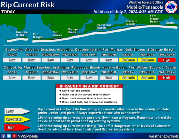
PLEASE pay attention to the Rip Current Flags System at each beach for the update on rip currents. Get the latest weather and rip current forecasts for the beaches from Fort Morgan to Panama City on our Beach Forecast Center page. There, you can select the forecast of the region that you are interested in visiting.
WORLD TEMPERATURE EXTREMES: Over the last 24 hours, the highest observation outside the U.S. was 122.7F at Hassi-Messaoud, Algeria. The lowest observation was -96.9F at Concordia, Antarctica.
CONTIGUOUS TEMPERATURE EXTREMES: Over the last 24 hours, the highest observation was 115F at Tecopa, CA. The lowest observation was 28F at Peter Sinks, UT.
Category: Alabama's Weather, ALL POSTS
About the Author (Author Profile)
Macon, Georgia Television Chief Meteorologist, Birmingham native, and long time Contributor on AlabamaWX. Stormchaser. I did not choose Weather, it chose Me. College Football Fanatic. @Ryan_StinnetSubscribe
If you enjoyed this article, subscribe to receive more just like it.


