

10 a.m. Info on Beryl: Hurricane Has Peaked but is Still Very Dangerous
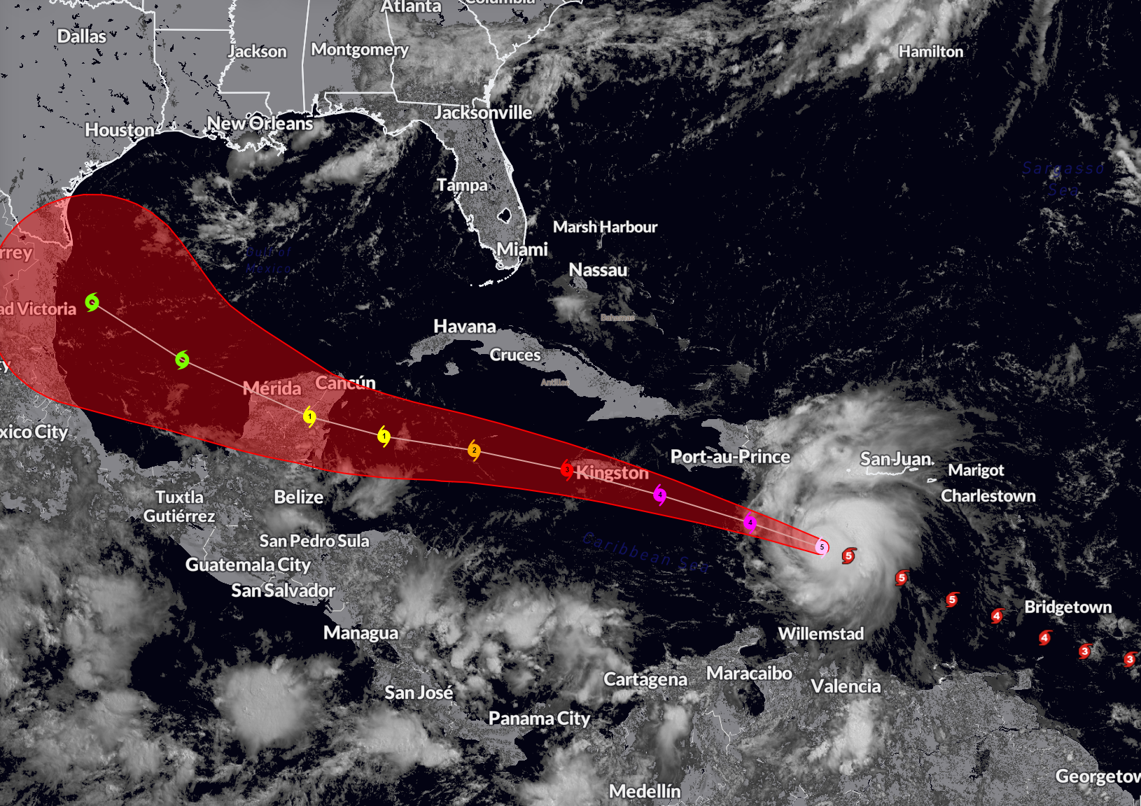
Beryl appears to have peaked in intensity this morning. It remains a dangerous category five hurricane with top winds of 160 mph, down from its peak of 165. The hurricane is moving on a steady west northwest track at 22mph. There does be a little jog to the south over the past few hours. Any distance further south will help reduce the impacts in Jamaica, Hispaniola, and the Caymans, but for now it is a really bad situation for Jamaica.
FAST FACTS ON BERYL
SUMMARY OF 1100 AM AST…1500 UTC…INFORMATION
———————————————–
LOCATION…15.3N 68.9W
ABOUT 235 MI…375 KM SE OF ISLA BEATA DOMINICAN REPUBLIC
ABOUT 555 MI…895 KM ESE OF KINGSTON JAMAICA
MAXIMUM SUSTAINED WINDS…160 MPH…260 KM/H
PRESENT MOVEMENT…WNW OR 290 DEGREES AT 22 MPH…35 KM/H
MINIMUM CENTRAL PRESSURE…938 MB…27.70 INCHES
Some dry air is beginning to work into the storm circulation. The hurricane should begin to slowly weaken as it encounters shear and some dry air over the Caribbean.
On its last past, the hurricane hunters found a central pressure of 939 millibars. They found a flight level wind to 169 mph on their outbound leg. This translates to 150 mph at the surface. The highest surface wind gust measured was 152 mph.
The eye is circular, 16 miles in diameter. The eye is open to the Southeast, which is a good sign.
Next up for Beryl is the southern coasts of the Dominican Republic and Haiti. Tropical storm force winds will impact the southwestern portion of the Dominican Republic around Barahona and Azua and Bani. Those winds could brush Santo Domingo, but for now, TS force winds are not expected there.
Tropical storm force winds will be felt in southern Haiti starting late this afternoon and continuing tonight.
Jamaica is under a hurricane warning. It will feel the direct impacts of Beryl. Max winds will be around 125-130 mph by then. Tropical storm force winds will begin about 7 a.m. CDT tomorrow. Strong tropical storm force winds will move onshore in eastern Jamaica around 10 a.m. tomorrow. Hurricane force winds will arrive around noon, with the eyewall scraping the southern half of the island during the afternoon. Kingston will be very close to experiencing the eyewall with sustained winds of 115-130 mph. Places like Negril, Savannah-la-Mer, Mandeville, The Alley, and May Pen will experience the full force of the eyewall with those sustained 115-130 mph winds. Gusts could reach 140 mph. Areas right along the coast may experience the eye. Storm surge heights in Jamaica will be 5-8 feet. Rainfall will be 4-8 inches with isolated amounts to 12 inches.
The center will pass south of the Caymans Thursday morning. Top winds by then should be 100-110 mph. Tropical storm force winds will start to arrive there around midnight tomorrow night, early Thursday, lasting about 12 hours. Strong tropical storm force winds will arrive around 4 a.m. lasting 4-5 hours. Peak winds at Grand Cayman will be 60-70 mph with gusts to 80 mph. Those peak winds should be 5-6 a.m. CDT Thursday.
From there it will impact the Yucatan beginning Thursday evening as a 90 mph hurricane. Cozumel will feel the impact first, with tropical storm force winds by 8 p.m. CDT Thursday. They should reach Cancun by midnight. Landfall should come around 4-5 a.m. CDT south of Cozumel. The center will pass near Merida Friday afternoon causing their winds to rise to 60-65 with gusts to hurricane force. It will then enter the southwestern Gulf.
The official NHC forecast carries it to near the northeast Mexican coast south of Brownsville Sunday morning as a strong tropical storm. Some of the models though bring the storm further north because of a weakness in the upper pattern over the Plains states of the U.S. It is no threat to Alabama or Northwest Florida based on the current forecast though.
Category: Alabama's Weather, ALL POSTS, Tropical
About the Author (Author Profile)
Bill Murray is the President of The Weather Factory. He is the site's official weather historian and a weekend forecaster. He also anchors the site's severe weather coverage. Bill Murray is the proud holder of National Weather Association Digital Seal #0001 @wxhistorianSubscribe
If you enjoyed this article, subscribe to receive more just like it.


